Monte Burney
| Monte Burney | ||
|---|---|---|
|
Monte Burney from the north (Ancón sin Salida) |
||
| height | 1758 m | |
| location | Región de Magallanes y de la Antártica Chilena ( Chile ) | |
| Mountains | To the | |
| Coordinates | 52 ° 19 '27 " S , 73 ° 22' 50" W | |
|
|
||
| Type | Stratovolcano (active) | |
| Last eruption | March 1910 | |
| First ascent | 1973 by Eric Shipton | |
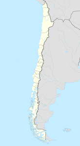
The Monte Burney is an ice-covered stratovolcano in southern Chile . It is located about 190 kilometers northwest of the city of Punta Arenas on the Muñoz-Gamero Peninsula in the Región de Magallanes y de la Antártica Chilena , south of the ridge of the Cordillera Sarmiento . It is the southernmost active volcano in the country, the South American continent and the entire Pacific Ring of Fire and was named in honor of the British Rear Admiral James Burney (1750-1821).
The volcanic activity in the region is due to the subduction of the Antarctic under the South American lithospheric plate . Monte Burney was formed on the western edge of a six kilometer wide caldera . It is the remnant of an originally much larger volcanic building that once collapsed in the course of an eruption. This collapse resulted in a large avalanche of debris that pushed in a south-southwest direction. The caldera is partially filled and has been bordered with unglaciated deposits of pyroclastic flows . There is an ice sheet on the mountain itself. Its size was reduced from 22.4 square kilometers in 1870 to 15.5 square kilometers in 2011. In addition, Monte Burney is characterized by a small summit crater and a comparatively steep northern flank.
Monte Burney is mainly composed of andesitic and basaltic rocks, but it also has Dacitic components with an SiO 2 content between 59 and 66 percent. At its base are pumice - sediments deposited. Eastern areas of the mountain consist of deposits of Holocene pyroclastic flows and possibly older volcanic rocks .
Radiocarbon studies provided evidence of two large Plinian eruptions with a VEI value of 5 during the Holocene , which date back to 7450 BC. BC ± 500 and 2320 BC Can be dated ± 100 BC. The only known eruption in post-Christian times occurred in March 1910. There is no urban settlement within a radius of at least 30 kilometers from Monte Burney, so that even in the case of extensive activity it does not pose any acute danger potential.
Web links
- Monte Burney in the Global Volcanism Program of the Smithsonian Institution (English)

