
Moodna Viaduct
Coordinates: 41 ° 25 ′ 49 ″ N , 74 ° 5 ′ 56 ″ W.
| Moodna Viaduct | ||
|---|---|---|
 |
||
| use | Railway bridge | |
| Crossing of | Moodna Creek | |
| place | Orange County (New York) | |
| Entertained by |
Metro-North Railroad (leased from Norfolk Southern , operated by NJ Transit ) |
|
| construction | Trestle Bridge | |
| overall length | 975 m | |
| Longest span | 24 m | |
| Clear height | 55 m ( HQ ) | |
| opening | 1909 | |
| planner | Mason R. Strong | |
| location | ||
|
||

The Moodna Viaduct (also Moodna Creek Viaduct ) is a single-track railway bridge over the valley of Moodna Creek . It is located on the north end of Schunemunk Mountain to the east of Orange County of New York state . The almost one kilometer long Trestle Bridge (scaffolding pier viaduct) made of steel was built by the Erie Railroad (ERIE) by the end of 1908 . It was part of a freight line with a low gradient from Highland Mills to Port Jervis (Graham Line) , which was put into operation in early 1909 to relieve the main line south of it. The ERIE merged in 1960 to the Erie Lackawanna Railroad , which had to file for bankruptcy in 1972 . In 1976 it came into the possession of the state rescue company Conrail along with other bankrupt railway companies . The suburban traffic of New York City was in New York from 1983 Metro-North Railroad and New Jersey by New Jersey Transit adopted. The passenger traffic to Port Jervis was shifted to the freight route. After the split of Conrail in 1999, the route including the Moodna Viaduct went to the Norfolk Southern Railway , which it leased to the Metro-North Railroad in 2003. The Port-Jervis line is operated by NJ Transit on behalf of Metro-North.
history
The Graham Line of the Erie Railroad
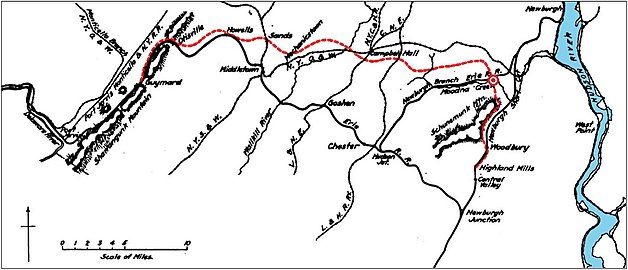
The Erie Railroad (ERIE), which originally ran between New York City and the eponymous Lake Erie , had expanded its route network to Cincinnati and Chicago by the end of the 19th century and wanted to expand the capacity of its main route in the state of New York to Port Jervis . Since the line here had gradients of over 10 ‰, which in some places required the use of additional push locomotives, the ERIE decided against a four-track upgrade and between 1905 and 1908 laid a partially double-track bypass route for goods traffic with a slight incline between Highland Mills and the Guymard Lake in the Shawangunk Mountains , where it reconnected to the main line about ten kilometers northeast of Port Jervis.
The Guymard Cut-Off (Graham Line ) of the Erie Railroad with the Moodna Viaduct , underneath the main line and on the right the Hudson (redesigned drawing from 1908)


The Erie Railroad network stretched from New York City to Chicago in 1896

_(14595209760).jpg)
Originally known as the Guymard Cut-Off , the 68-kilometer route had gradients of no more than 6 ‰ and was opened in January 1909; in honor of ERIE's chief engineer, James Graham, who died a month later, it was later renamed Graham Line . To avoid steep gradients, the Otisville Tunnel and several bridges had to be built at the highest point . The largest of these was built at the lowest point over the valley of Moodna Creek . The almost one kilometer long Moodna Viaduct led the route at the northern end of Schunemunk Mountain at a height of over 55 meters over the valley. The steel lattice masts of the Trestle Bridge were designed for a later double-track expansion, but this was never implemented.
Takeover by Conrail and maintenance by Metro-North
.jpg)

With the expansion of the road network in the USA and the emergence of motorized individual transport, the railroad transported fewer and fewer goods and people, which from the 1960s onwards made the large railroad networks in North America increasingly unprofitable and subsequently led to several bankruptcies and mergers of the railway companies. The ERIE merged in 1960 to the Erie Lackawanna Railroad , which had to file for bankruptcy in 1972 after severe damage to the railway systems by cyclone Agnes . In 1976 it came into the possession of the state rescue company Conrail along with other bankrupt railway companies . The suburban traffic of New York City was in New York from 1983 Metro-North Railroad and New Jersey by New Jersey Transit adopted. The passenger traffic to Port Jervis was shifted from the main line to the freight line. This was better suited due to its lower gradient, but had neither train stations nor suitable transport connections for commuters, which had to be built and which were expanded in the following years; the main line was closed. After Conrail split up in 1999, the route including the Moodna Viaduct was taken over by the Norfolk Southern Railway , which leased it to the Metro-North Railroad in 2003. With the necessary repair work in 2010–2014, the regional train ensured the operation of the old steel structure for another 20 years, but according to the Metropolitan Transportation Authority , a new building will be necessary by 2034 . The Port-Jervis Line is maintained by Metro-North, but the train service is carried out by NJ Transit and is the northern extension of the Main & Bergen County Lines . In 2017, 27 trains ran here every day on weekdays. Passenger numbers have doubled since 1984 and were around one million a year in 2015.
description
The Moodna Viaduct is a trestle bridge (scaffolding pier viaduct ) that rests on 26 steel lattice masts. The track level runs on two parallel solid wall girders each , which are mounted symmetrically to the central axis of the viaduct at a distance of one meter. The 26 steel girders on the masts are 12.2 m long and 1.7 m high. The 27 girders between the masts are 2.7 m high due to their double length. Over a length of 73.2 m, two long and two short girders are connected to each other between a fixed and a floating bearing . The total length of the Trestle Bridge between the abutments is 975.4 m.

The steel lattice masts vary in height from 11 m on the edges of the valley to 55 m above Moodna Creek. Since they were designed for a later double-track expansion, they are almost 6 m wide at the top. The footprint of the tallest masts at the level of their foundations is 24.4 m × 19.8 m. The masts each stand on four separate concrete bases, with two of the six bases on Moodna Creek connected in the direction of the river by an additional concrete wall and reinforced at the ends to protect against ice drift . The total mass of steel used was around 3670 tons.
See also
literature
- The Moodna Creek Viaduct, Erie RR In: Engineering Record. Vol. 56, No. 1, 1907, pp. 7-9.
- The Erection of the Moodna Creek Viaduct. In: Engineering Record. Vol. 56, No. 17, 1907, pp. 451 f.
- The Guymard cut-off. In: Railroad Age Gazette. Vol. 45, No. 23, 1908, pp. 1292-1295.
Web links
- Erie Railway, Moodna Creek Viaduct, Moodna Creek, Orrs Mill Road, Salisbury Mills, Orange County, NY. HAER NY-62, Library of Congress.
Individual evidence
- ↑ a b c The Guymard Cut-off. In: Railroad Age Gazette. Vol. 45, No. 23, 1908, pp. 1292-1295.
- ^ A b Robert McCue: Erie Railroad's Newburgh Branch. Arcadia Publishing, 2014, ISBN 978-1-4396-4605-2 , p. 9.
- ↑ MTA Twenty-Year Capital Needs Assessment 2015-2034. Metropolitan Transportation Authority, 2013, p. 76 f.
- ↑ Khurram Saeed: NJ Transit, Metro-North reach service deal. Brotherhood of Locomotive Engineers and Trainmen, June 21, 2006. Retrieved August 18, 2019.
- ^ Port Jervis Line Strategy Report. Metro-North Railroad, January 2018, pp. 5–9. Retrieved August 18, 2019.
- ↑ a b The Moodna Creek Viaduct, Erie RR In: Engineering Record. Vol. 56, No. 1, 1907, pp. 7-9.