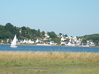
Morlaix (English Channel)
|
Morlaix Jarlot |
||
|
It flows into the Rade de Morlaix |
||
| Data | ||
| Water code | FR : J26-0300 | |
| location | France , Brittany region | |
| River system | Morlaix | |
| source | in the municipality of Plougonven 48 ° 28 ′ 52 ″ N , 3 ° 43 ′ 26 ″ W |
|
| Source height | approx. 240 m | |
| muzzle | at Locquénolé in the English Channel Coordinates: 48 ° 37 ′ 42 " N , 3 ° 50 ′ 57" W 48 ° 37 ′ 42 " N , 3 ° 50 ′ 57" W |
|
| Mouth height | 0 m | |
| Height difference | approx. 240 m | |
| Bottom slope | approx. 10 ‰ | |
| length | 24 km | |
| Catchment area | 233 km² | |
| Left tributaries | Queffleuth , Pennélé | |
| Right tributaries | Tromorgant | |
| Small towns | Morlaix | |
| Navigable | to Morlaix | |
The Morlaix (in the upper reaches: Jarlot ) is a coastal river in France that runs in the Finistère department in the Brittany region . It rises west of the hamlet Le Quillou in the municipality of Plougonven and generally drains in a north-westerly direction through the Armorique Regional Nature Park . In the town of Morlaix , the river also takes the name Morlaix , forms a confluence and reaches the English Channel at Locquénolé after a total of 24 kilometers in the Rade de Morlaix bay . The river Dourduff , which flows there from the right , is according to official information not a tributary of the Morlaix, but an independent coastal river.
Places on the river
(in flow order)
Attractions
- Viaduc de Morlaix railway viaduct over the river - Monument historique
- Suscinio Botanical Garden (fr: Parc botanique de Suscinio ) at the mouth of the river
Individual evidence
- ↑ Source geoportail.gouv.fr
- ↑ estuary geoportail.gouv.fr
- ↑ a b c The information on the river length is based on the information about the Morlaix at SANDRE (French), accessed on March 12, 2013, rounded to full kilometers.
- ↑ Viaduc de Morlaix in the Base Mérimée of the French Ministry of Culture (French)


