Mount Maw
| Mount Maw | ||
|---|---|---|
|
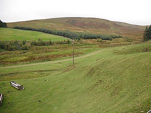
Flank of Mount Maw |
||
| height | 535 m ASL | |
| location | Scottish Borders , Scotland | |
| Mountains | Pentland Hills | |
| Coordinates | 55 ° 47 '6 " N , 3 ° 22' 14" W | |
|
|
||
The Mount Maw is a hill in the Pentland Hills . The 535 m high elevation is on the eastern flank of the southern part of the approximately 25 km long range of hills in the Scottish Council Area Scottish Borders .
The closest village is the hamlet of Carlops, about two kilometers to the west . West Linton is four kilometers south. The surrounding hills include the Grain Heads in the north, Patie's Hill in the northeast, Faw Mount in the south and the Byrehope Mount in the southwest.
Surroundings
Several streams arise on the flanks of Mount Maw. One of these streams feeds the Baddinsgill Reservoir , located off the west flank . Two more streams flow directly south of the reservoir into the outflowing Lyne Water . Two springs on the eastern flank feed the North Esk .
On the eastern flank, the discovery of a worked flint wedge testifies to earlier settlement. During the time of the Roman occupation of Britain , a Roman road ran along the eastern flank . Its fortification dam can still be seen in parts. A tunnel was driven into the hill at the same height. Presumably it is a prospecting tunnel for exploring lead mining . Silver was also probably mined there.
Individual evidence
- ^ Entry in the Gazetteer for Scotland
- ↑ Entry on Castlelaw in Canmore, the database of Historic Environment Scotland (English)
- ↑ Entry on Hollow Haugh in Canmore, the database of Historic Environment Scotland (English)
- ↑ Entry on Jenny Barry's Cove in Canmore, the database of Historic Environment Scotland (English)

