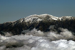
Mount San Antonio
| Mount San Antonio | ||
|---|---|---|
|
Mount San Antonio above the clouds |
||
| height | 3069 m | |
| location | California , USA | |
| Mountains | San Gabriel Mountains | |
| Coordinates | 34 ° 17 '20 " N , 117 ° 38' 48" W | |
|
|
||
| rock | granite | |
| Normal way | Ski lift to Baldy Notch, Devil's Backbone Path | |
Mount San Antonio , also known as Old Baldy or Mount Baldy , is the highest peak in the San Gabriel Mountains at 3,069 meters , and the highest point in Los Angeles County , California . The sometimes snow-capped summit of Mount San Antonio is also visible in Los Angeles on a clear day and is a dominant eye-catcher from the city.
geography
Mount San Antonio has two peaks. The higher of the two has a height of 3069 meters. The lower, West Baldy, reaches 3,044 meters. Nearby are the San Antonio stream and the San Antonio waterfalls.
history
The summit marks the borderline between the counties of San Bernardino County and Los Angeles County and is known as Baldy , so a so-called "bald man", because no trees grow on its summit. The Tongva tribe call the mountain Yoát or Joat , which means something like "snow". The Mohave call him Avii Kwatiinyam .
Between 1922 and 1927, the American physicist Albert A. Michelson carried out a series of experiments in which a beam of light was thrown onto a reflector on the Lookout Mount ; the previously determined distance between the two points enabled a very precise calculation of the speed of light, which was 299,796 Was ± 4 km / s.
Mount Baldy Ski Lifts , the family-owned ski area , is the closest ski area to Los Angeles on Mount San Antonio along Thunder Mountain . Close by is Mount Baldy Village, a small community with its own fire department , church, visitor center and a small school with 88 students.
The mountain is named after Anthony of Padua .
Hiking and mountaineering
Three different hiking trails provide access to the summit, the most famous of which is the Baldy Bowl Route from the southeast. A route is also "supported" by a lift on summer weekends. Many of the foothills also allow mountaineering and bouldering . There are also several "adventure trails".
For mountaineers, the mountain, especially the Baldy Bowl route, offers a special challenge in winter and spring. The 45 ° to 50 ° steep slopes can only be climbed in good snow conditions.
Web links
Individual evidence
- ↑ West Baldy, California on Peakbagger.com (English). Retrieved August 14, 2009.
- ↑ San Antonio Falls ( English ) In: Geographic Names Information System . United States Geological Survey . Retrieved August 14, 2009.
- ^ Official Boundaries of the County of Los Angeles . In: Los Angeles Almanac . Retrieved August 30, 2008.
- ↑ Pamela Munro, Nellie Brown, and Judith G. Crawford: A Mojave dictionary . In: University of California, Los Angeles (Ed.): UCLA occasional papers in linguistics . no.10 , Los Angeles, 1992. OCLC 28561333 .
- ↑ Lookout Mountain ( English ) In: Geographic Names Information System . United States Geological Survey . Retrieved August 14, 2009.
- ↑ CL, Captain (retired) Garner: A Geodetic Measurement of Unusually High Accuracy (PDF; 5.4 MB) Coast and Geodetic Survey. Pp. 68-74. April 1949. Retrieved August 13, 2009.
- ^ Mt Baldy School . Mt Baldy School District. Retrieved August 14, 2009.
- ↑ http://www.summitpost.org/route/414208/san-antonio-ski-hut-baldy-bowl-route.html


