
Mount Spurr
| Mount Spurr | ||
|---|---|---|
 View from the east of Mount Spurr; in the foreground the Crater Peak |
||
| height | 3374 m | |
| location | Alaska (USA) | |
| Mountains | Tordrillo Mountains | |
| Dominance | 14.85 km → Mount Torbert | |
| Notch height | 585 m ↓ (2789 m) | |
| Coordinates | 61 ° 17 ′ 56 " N , 152 ° 15 ′ 14" W | |
|
||
| Type | Stratovolcano | |
| rock | Andesite | |
| Last eruption | 1992 | |

The Mount Spurr is a 3374 m high stratovolcano in the Tordrillo Mountains in Alaska . It was formed in the caldera of an older volcano, which has a diameter of up to 6 km and a height of 3000 m .
geography
In addition to the main peak with the 2309 m high Crater Peak ( ⊙ ), Mount Spurr has a second eruption vent that was formed in a rupture of the old caldera. While the main peak has been inactive for over 5,000 years, the last eruptions on Crater Peak were in 1953 and 1992, which led to ash rain as far as Anchorage , 130 km to the east .
The foot area of Mount Spurr is covered by pyroclastic deposits with eruptive dikes and volcanic bed dikes, the flanks of andesitic lava flows.
The mountain is named after Josiah Edward Spurr , a geologist with the United States Geological Survey , who led an expedition to the area in 1898. The proximity of Mount Spurr to transpacific flight routes harbors potential dangers for air traffic.
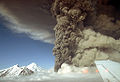
Eruption of Crater Peak in August 1992

The Crater Peak with the main peak in the background


Web links
- Mount Spurr in the Global Volcanism Program of the Smithsonian Institution (English)
- Mount Spurr in the United States Geological Survey's Geographic Names Information System
- Mount Spurr, Alaska on Peakbagger.com (English)
- Mount Spurr / Alaska Volcano Observatory
- Mount Spurr webcam