Tordrillo Mountains
| Tordrillo Mountains | ||
|---|---|---|
|
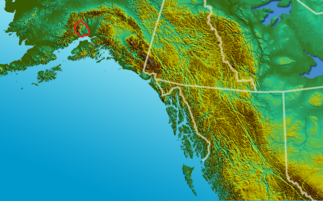
Tordrillo Mountains (outlined in red) |
||
| Highest peak | Mount Torbert ( 3479 m ) | |
| location | Alaska ( USA ) | |
|
|
||
| Coordinates | 61 ° 29 ′ N , 152 ° 25 ′ W | |
| surface | 9,992 km² | |
|
Mount Spurr in the Tordrillo Mountains |
||
The Tordrillo Mountains are a mountain range in the region South Central of Alaska , about 120 km west-northwest of Anchorage .
They are located on the west coast of the Cook Inlet and cover an area of 9992 km² with an extension of 119 km in north-south and 130 km in east-west direction. The highest mountain in the Tordrillo Mountains is Mount Torbert with a height of 3479 m . The mountain group is often assigned to the Alaska range .
In the south, the Tordrillo Mountains border on the Chigmit Mountains and Neacola Mountains , which represent the northernmost area of the Aleutian chain . To the west and north are the southern foothills of the Alaska range. The largest ice masses in the heavily glaciated mountain range include Capps , Triumvirate , Hayes and Trimble glaciers .
The Tordrillo Mountains , like the Aleutian Range, are mainly of volcanic origin. However, Mount Torbert is not a volcano. The Mount Spurr , the southernmost peak of the mountain range, in 1992 had been its last eruption. Another volcano is the glacier-covered Hayes .
The north flank of the Tordrillo Mountains belongs to the catchment area of the Skwentna River , the water on the south side flows over the Chakachamna Lake and the Chakachatna River to the Cook Inlet .
Mountains of the Tordrillo Mountains
- Mount Torbert ( 3479 m )
- Mount Gerdine ( 3431 m )
- Mount Talachulitna ( 3383 m )
- Mount Spurr ( 3374 m )


