
Mrauk U
| မြောက် ဦး Mrauk U |
|||
|---|---|---|---|
|
|||
| Coordinates | 20 ° 35 ' N , 93 ° 12' E | ||
| Basic data | |||
| Country | Myanmar | ||
|
State |
Rakhine State | ||
| ISO 3166-2 | MM-16 | ||
 |
|||

_no_primeiro_plano_o_bairro_portugu%C3%AAs.jpg)
Mrauk U ( Burmese မြောက် ဦး မြို့ , BGN / PCGN : myauk-umyo, formerly Mrohaung ) is an archaeologically important city within the Rakhine State in western Myanmar . It lies east of the Kaladan River and is circled by hills to the north and south.
history
In 1430, King Min Saw Mon founded the place, which under the name Mrohaung served as the capital of the last united Arakan kingdom until 1785 . Mrohaung reached a population of around 120,000 during the mid-16th century. The city traded with Ava , Pegu , Portugal, the Netherlands, Arabia, Persia and India. The goods traded were rice, cotton, rubies, elephants, slaves, horses, ivory, cowrie shells and spices. This is particularly described by the Dutch ship doctor of the Dutch East India Company (VOC) Wouter Schouten in his book "The Journey to East India" from 1676.
At the time of its peak, Mrauk U controlled half of Bangladesh , including Dhaka and Chittagong , today's Rakhine state and the western part of Lower Burma. During this period the kings minted coins in Akaranese script and Bengali in Kufic script. During the flowering period, many pagodas and temples were built that still exist today. The most notable are the Shite Thaung Temple (Temple of 80,000 Images or Temple of Victory), the Htukmuthein Temple (Htukkanthei Ordination Hall), the Koe Thaung Temple (Temple of 90,000 Images), the Laymyethna Temple , the Five Mahn Pagodas of Mahn , Laung Bwann Brauk Pagoda , Sakya Man Aung Pagoda and Theindaung Pagoda . A Buddha figure is still preserved from the Anawma Pagoda , which was built in 1501 . The Khrain Kaik Pitakataik library was established in 1591.
The Burmese King Tabishwehti attacked Mrauk U from 1546 to 1547, in 1784 King Bodawpaya carried out a storm on the city, which Mrauk U finally brought down on January 2, 1785.
When the British moved the administrative center to Akyab in the 19th century , the decline of Mrauk U began. The city was named Mrohaung (Old City), it was not renamed Mrauk U until 1979. Mrauk U means monkey egg, which in the Arakanese language was a name for "potato".
present
The area around Mrauk U is the second most important rice production site in Myanmar after the Irrawaddy Delta. Today, Mrauk U is primarily an archaeological site. It is about a two-day trip from Yangon or a 3-5 hour boat ride from Akjab across the Kalanda River. A large number of pagodas (including the Pizi Phara Pagoda ), temples and religious buildings have been preserved around Mrauk U, and they have been built since the foundation in 1431.
Mrauk U is predominantly a Buddhist site. The Santikan Mosque (Sindhi Khan Mosque) southeast of the city dates from the 15th / 16th centuries. Century.
Picture gallery

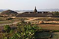
View of Mrauk U

Shite-thaung temple

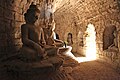
Htukkanthein Temple

Buddha statue in Htukkanthein Temple
Koe-thaung Temple
Le-myet-hna temple

Ratana-pon


See also
- Dhanyawadi , first capital of the Arakan Empire from the 5th to the 8th centuries
literature
- Michael W. Charney: Crisis and Reformation in a Maritime Kingdom of Southeast Asia: Forces of Instability and Political Disintegration in Western Burma (Arakan), 1603–1701. In: Journal of the Economic and Social History of the Orient, Vol. 41, No. 2. 1998, pp. 185-219
- Jos Gommans: The maritime frontier of Burma: exploring political, cultural and commercial interaction in the Indian Ocean World, 1200–1800 . (Negotiations of the Koninklijke Nederlandse Akademie van Wetenschappen, Afd. Letterkunde; NR, 185). Koninklijke Nederlandse Akad. Van Wetenschappen, Amsterdam 2002. ISBN 978-9069843285
- U Shwe Zan: The golden Mrauk U. An ancient Capital of Rakhine. Rakhine Thahaya Association, Rangoon 1997
Web links
- History of Mrauk U. myanmars.net
Individual evidence
- ↑ Jos Gommans: The maritime frontier of Burma: exploring political, cultural and commercial interaction in the Indian Ocean World, 1200-1800 . P. 133