Mu Gia pass
| Mu Gia pass | |||
|---|---|---|---|
| Compass direction | North | south | |
| Pass height | 418 m | ||
| District | Minh Hóa , Quảng Bình , Vietnam | Bualapha, Khammuan , Laos | |
| Watershed | Gianh River | Nam hay | |
| Valley locations | Tân Ấp | Ban Nongchan | |
| expansion | Pass road, China-Laos Railway (planned), Laos-Vietnam Railway (planned) |
||
| Map (Khammuan) | |||
|
|
|||
| Coordinates | 17 ° 40 ′ 19 " N , 105 ° 45 ′ 56" E | ||
The Mụ Giạ pass ( Vietnamese : Đèo Mụ Giạ , Lao : Anma Mouya ) is a mountain pass in the Truong Son Mountains , which connects Vietnam with Laos . The pass played an important role during the wars in Vietnam, so that the traffic route was destroyed several times during the fighting.
course
The Mu Gia Pass is located approximately 90 km northwest of Dong Hoi , capital of the Qu Provinzng Bình province in central Vietnam, and 50 km east of Thakhek , capital of the Lao province of Khammuan .
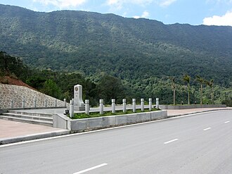
In the highlands of North Vietnam, National Road 12A, formerly known as National Road 15, winds south from Tân Ấp to the Mu Gia Pass. It follows the Gianh River in a narrow valley with steep slopes. On the east side there are limestone peaks that look like the teeth of a dog , on the west side there is a plateau. Dense tropical rainforest covers the entire area. The road is laid in the steep valley flank, because in most places there is not enough space at the bottom of the gorge for the road and the Gianh River, which is still more of a stream here.
The pass is at 418 m and used to be the site of a North Vietnamese barracks . Beyond the top of the pass, the Laotian National Road 12 descends to Laos.
history

The road over the pass was already expanded during the French colonial era and was accessible by trucks in the 1960s . However, in the rainy season from early June to mid-December, traffic was severely restricted or not possible at all due to landslides .
The pass was the most important entry point into the Ho Chi Minh Trail , along with the Nape Pass further north . This road and traffic route system through Laos towards South Vietnam served as an important supply line for North Vietnam in the Indochina War and the Vietnam War to support the fighters in the south. Due to the difficult terrain on the north side of the Mu-Gia Pass, the CIA identified the eye of the needle on the Ho Chi Minh Path and destroyed the road several times in the course of several air strikes by the American and South Vietnamese air forces .
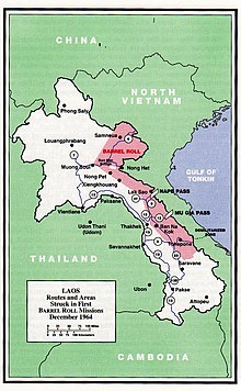
The first bombings took place in the secret mission Operation Barrel Roll , which was carried out parallel to the Vietnam War on Laotian soil , followed by continuous bombing during Operation Rolling Thunder and another secret mission, Operation Commando Hunt, on Laotian soil.
In June 1965 truck traffic over the pass came to a standstill after the US Air Force had made the road unusable with daily air raids. In March 1966 it was estimated that 75% of all truck traffic to Laos was again handled through the pass.
On April 12, 1966, 29 long-range Boeing B-52 bombers attacked the pass for the first time. It was the largest bomber attack since World War II . Over a five-kilometer section of the road were bombs with delay fuse thrown that should detonate only after entering the earth rich. The hoped-for landslides did not materialize, so the traffic route was not interrupted. Another attack took place on April 26th, but the damage was repaired overnight within ten hours and military convoys were again driving over the pass 24 hours after the attack. The communists went out of their way to keep the connection open. Despite frequent bombing by the US Air Force and the US Navy , the American armed forces never succeeded in making the Mu-Gia Pass impassable for a long time.
The Vietnamese People's Army built several bypass roads east and west of the Mu-Gia Pass as an alternative to the repeatedly bombed road. Several pipelines for gasoline, oil and lubricants were later built across the pass. Air defense was also expanded. First small-caliber anti - aircraft guns were used, later large-caliber 100 mm guns. In 1966 more than 300 anti-aircraft positions could be identified. From 1972 the Soviet S-75 surface-to-air missiles were also used. This meant that the B-52 and the attack helicopters could no longer fly so high, but rather came within range of the anti-aircraft positions. Nearly 50 aircraft were shot down over the pass during the fighting.
The valley south of the pass in Laos was a " doghouse " kennel called. The name came from the fact that the boundaries of this area were reminiscent of the shape of a dog house. Here the Vietnamese People's Army maintained numerous storage sites and caves that were used to store material. Given the importance of the doghouse, there were many anti-aircraft gun positions in the area.
Web links
- Ray Smith: Map of the north side of the Mu Ghia Pass. (Interactive). In: Ray's Map Room.
- Ray Smith: Map of the south side of the Mu Gia Pass. (Interactive). In: Ray's Map Room.
- Ray Smith: Mu Ghia Pass card. (Interactive). In: Ray's Map Room.
Individual evidence
- ^ RJ Smith: Northern Mu Ghia Pass. Map. Retrieved November 8, 2018 .
- ^ A b Arthur R Hall: Landscape Analysis. CIA (English).
- ^ A b c Jacob Van Staaveren: Interdiction in Southern Laos 1960-1968 . Center for Air Force History, 1993, ISBN 978-1-4102-2060-8 , pp. 135-137.
- ↑ a b CIA (ed.): Buildup of Vietnamese Communist Forces continues after resumption of air attacks . Intelligence Memorandum. February 21, 1966, Supply Routes in Laos, p. 10 ( ttu.edu [PDF]).
- ↑ CIA (ed.): Interdiction of Communist Infiltration Routes in Vietnam . Intelligence Memorandum. ( ttu.edu [PDF]).
- ^ CIA (ed.): An Appraisal of the Bombing on North Vietnam . May 21, 1966 ( ttu.edu [PDF]).
- ↑ Bernard Nalty: The War Against Trucks: Aerial Interdiction in Southern Laos from 1968 to 1972 . Air Force History & Museums Program, 2005, ISBN 978-0-16-072493-0 , pp. 98, 130, 157-8, 181, 218-19, 228.
- ↑ Ho Chi Minh Trail Before and Now Photos. In: Explore Indochina. Retrieved November 8, 2018 .
- ↑ Mu Ghia Pass - Ho Chi Minh Trail. Retrieved November 8, 2018 .

