Municipio Bolívar
| Municipio Bolívar | ||
|---|---|---|
| Basic data
|
||
| Population (state) - population density |
7,279 inhabitants (2012 census) 10 inhabitants / km² |
|
| Post Code | 03-1501 | |
| Telephone code | (+591) | |
| surface | 701 km² | |
| height | 4000 m | |
| Coordinates | 18 ° 0 ′ S , 66 ° 36 ′ W | |
|
|
||
| politics
|
||
| Department | Cochabamba | |
| province | Bolívar | |
| Central place | Bolívar | |
| climate | ||
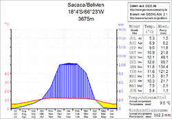
 Climate diagram Sacaca |
||
The Municipio Bolívar is a district in the department of Cochabamba in the South American Andean state of Bolivia .
Location in the vicinity
The municipality of Bolívar is the only municipality in the province of Bolívar . It is bordered by the Oruro department to the west, the Potosí department to the south and southeast , and the Arque province to the north .
The central place and largest settlement in the municipality is Bolívar with 484 inhabitants in the eastern part of the district. ( 2012 census )
geography
The Municipio Bolívar is located east of the Bolivian Altiplano in the northern part of the Bolivian Cordillera Central . The climate is a typical time of day climate in which the daily temperature fluctuations are greater than the seasonal fluctuations.
The annual precipitation is about 550 mm (see climate diagram Sacaca), with a distinct dry season from April to October with less than 20 mm monthly precipitation, and a short wet season in January and February with precipitation well over 100 mm. The mean average temperature of the region is 9.5 ° C and fluctuates only slightly between 5 ° C in June / July and 12 ° C in November / December.
population
The population of the Municipio Bolívar has changed little in the past two decades:
| year | Residents | source |
|---|---|---|
| 1992 | 7,081 | census |
| 2001 | 8,635 | census |
| 2012 | 7,279 | census |
The population density of the municipality at the last census of 2012 was 10.4 inhabitants / km², the proportion of the urban population was 0 percent, the life expectancy of newborns in 2001 was 48.7 years.
The literacy rate among those over 19 is 60.2 percent, namely 81.7 percent for men and 39.9 percent for women (2001) .
politics
Results of the elections to the municipal council ( concejales ) in the regional elections on April 4, 2010:
| Eligible voters | be right | valid | MAS -IPSP | POKUY | ||
|---|---|---|---|---|---|---|
| 3,794 | 3,338 | 2,419 | 1,726 | 693 | ||
| 100% | 72.5% | 71.4% | 28.6% |
structure
The municipality was subdivided in the last census of 2012 in the following nine cantons ( cantones ):
- 03-1501-01 Bolívar canton - 11 towns - 1,576 inhabitants ( 2001: 3,437 inhabitants )
- 03-1501-02 Canton Carpani - 22 villages - 852 inhabitants ( 2001: 620 inhabitants )
- 03-1501-03 Canton Comuna - 2 villages - 220 inhabitants ( 2001: 954 inhabitants )
- 03-1501-04 Canton Coyuna - 8 towns - 507 inhabitants ( 2001: 60 inhabitants )
- 03-1501-05 Canton Challoma - 6 towns - 399 inhabitants ( 2001: 242 inhabitants )
- 03-1501-06 Canton Jorenko - 6 villages - 491 inhabitants ( 2001: 665 inhabitants )
- 03-1501-07 Canton Vilacayma - 17 towns - 832 inhabitants ( 2001: 541 inhabitants )
- 03-1501-08 Canton Villa Victoria - 9 towns - 983 inhabitants ( 2001: 904 inhabitants )
- 03-1501-09 Canton Yarbicoya - 13 villages - 1,419 inhabitants ( 2001: 1,181 inhabitants )
Localities in the municipality of Bolívar
- Bolívar Canton
- Bolívar 484 pop.
Individual evidence
- ^ INE - Instituto Nacional de Estadística Bolivia 1992
- ^ INE - Instituto Nacional de Estadística Bolivia 2001
- ^ INE - Instituto Nacional de Estadística Bolivia 2012
- ↑ Acta de computo Nacional Electoral Departamentales, Municipales y Regional 2010
Web links
- Municipio Bolívar - General Maps No. 31501
- Municipio Bolívar - detailed map and population data (PDF; 374 kB) ( Spanish )
- Departamento Cochabamba - Social data of the municipalities (PDF 7.58 MB) ( Spanish )
