Municipio Potosí
| Municipio Potosí | ||
|---|---|---|
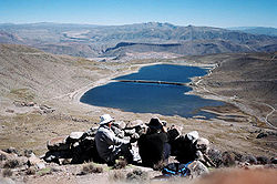
 Lagunas de Kari Kari |
||
| Basic data
|
||
| Population (state) - population density |
189,652 inhabitants (2012 census) 152 inhabitants / km² |
|
| Post Code | 05-0101 | |
| Telephone code | (+591) | |
| surface | 1,246 km² | |
| height | 3900 m | |
| Coordinates | 19 ° 35 ′ S , 65 ° 43 ′ W | |
|
|
||
| politics
|
||
| Department | Potosí | |
| province | Tomás Frías Province | |
| Central place | Potosí | |
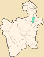
 Location of the Municipio Potosí in the department |
||
| climate | ||
 Climate diagram Potosí |
||
The Municipio Potosí is a district in the Potosí Department in the highlands of the South American Andean state of Bolivia .
Location in the vicinity
The Municipio Potosí is one of four Municipios in the Tomás Frías Province . It borders on the municipality of Yocalla to the west, the municipality of Tinguipaya to the north, the province of Cornelio Saavedra to the east, the province of José María Linares to the south, and the province of Antonio Quijarro to the southwest .
The central place of the municipality is the city of Potosí with 174,973 inhabitants ( 2012 ) in the western, central area of the district.
geography
The municipality of Potosí is located in the eastern part of the Bolivian Altiplano between the Andean high mountain ranges of the Cordillera Occidental in the west and the Cordillera Central in the east. The climate is semi-arid and a typical time of day climate , in which the daily temperature fluctuations are more pronounced than the seasonal fluctuations.
The average annual temperature in the municipality of Potosí is 11.4 ° C (see Potosí climate diagram), the monthly values vary between 8 ° C in June / July and a good 13 ° C from November to March. The annual precipitation is only about 350 mm, whereby in the summer months from April to October there is less than 15 mm of precipitation, and only the period from December to February has significant monthly precipitation between 60 and 80 mm.
population
The population of the Municipio Potosí has increased by about half in the past two decades:
- 1992 : 123,381 inhabitants ( census )
- 2001 : 145,057 inhabitants (census)
- 2012 : 189,652 inhabitants (update)
The life expectancy of newborns is 63 years, the literacy rate for those over 15 years of age is 89 percent, and the proportion of the urban population in the municipality is 92 percent. ( 2001 )
politics
Results of the elections for the municipal council ( concejales del municipio ) in the regional elections on April 4, 2010:
| electoral legitimate |
electoral participation |
valid votes | AS | MAS-IPSP | FCRP | ACU | SPP | MSM | ||
|---|---|---|---|---|---|---|---|---|---|---|
| 108.020 | 93,363 | 70,585 | 32,400 | 24,419 | 6,487 | 3,217 | 3,108 | 954 | ||
| 86.4% | 75.6% | 45.9% | 34.6% | 9.2% | 4.6% | 4.4% | 1.4% |
structure
The municipality is divided into the following four cantons ( cantones ):
- 05-0101-01 Canton Potosí - 52 localities - 179.901 inhabitants - central place: Potosí
- 05-0101-02 Canton Tarapaya - 12 villages - 764 inhabitants - central place: Tarapaya
- 05-0101-03 Canton Huari Huari - 19 villages - 3,152 inhabitants - central place: Huari Huari
- 05-0101-04 Canton Chulchucani - 76 localities - 5,835 inhabitants - central place: Chiltera Grande
Localities in the municipality of Potosí
- Canton of Potosí
- Potosí 174,973 pop - Santiago de Ockoruro 477 pop - Jesús de Machaca 444 pop - Agua Dulce 257 pop - San Andrés de Machaca 217 pop.
- Tarapaya Canton
- Tarapaya 96 pop.
- Huari canton Huari
- Huari Huari 915 pop - Chaquilla Alta 613 pop
- Canton of Chulchucani
- Karachipampa 798 pop - Manquiri 420 pop - Chiltera Grande 161 pop
Individual evidence
- ↑ Instituto Nacional de Estadística (INE) 1992
- ^ Instituto Nacional de Estadística (INE) 2001
- ↑ Instituto Nacional de Estadística (INE) 2012 ( Memento of the original of July 22, 2011 in the Internet Archive ) Info: The archive link has been inserted automatically and has not yet been checked. Please check the original and archive link according to the instructions and then remove this notice.
- ↑ Acta de computo Nacional Electoral Departamentales, Municipales y Regional 2010
Web links
- Municipio Pucarani - General Maps No. 50101
- Municipio Potosí - detailed map and population data (PDF; 722 kB) ( Spanish )
- Department Potosí - social data of the municipalities (PDF; 5.23 MB) ( Spanish )
