Municipio of San Francisco de los Romo
| San Francisco de los Romo | ||
|---|---|---|

|
||
| Symbols | ||
|
||
| Basic data | ||
| Country | Mexico | |
| State | Aguascalientes | |
| Seat | San Francisco de los Romo | |
| surface | 139.5 km² | |
| Residents | 35,769 (2010) | |
| density | 256.5 inhabitants per km² | |
| founding | 1991 | |
| INEGI no. | 01011 | |
| politics | ||
| Presidente municipal | Irais Martínez de la Cruz | |
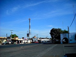
| Street through San Francisco de los Romo | ||
Coordinates: 22 ° 3 ′ N , 102 ° 15 ′ W
San Francisco de los Romo is the name of one of the eleven municipalities in the Mexican state of Aguascalientes . The administrative seat and largest place of the municipality is the eponymous San Francisco de los Romo . The municipality has 35,769 inhabitants (2010) and covers an area of 139.5 km².
geography
The municipality of San Francisco de los Romo is centrally located in the state of Aguascalientes in the Zona Metropolitana de Aguascalientes at an altitude between 1800 m and 2100 m . It belongs entirely to the physiographic province of the Mesa del Centro . The municipality is located in the catchment area of the Río Lerma and thus drains into the Pacific . The geology of the municipality consists of 44% alluvion , 41% sedimentary rock and 11% rhyolite tuff ; Soil type of 35% of the municipality is the Durisol with 32% Phaeozem and 22% Kastanozem . 63% of the community area is used for arable farming, about 33% as pasture land.
The municipality of San Francisco de los Romo borders the municipalities of Pabellón de Arteaga , Asientos , Aguascalientes and Jesús María .
population
The 2010 census counted 35,769 people in 8,438 residential units in the municipality. Of these, 74 people were registered as speakers of an indigenous language , including 13 speakers of the Nahuatl . About 4.7% of the population were illiterate. 13,204 inhabitants were registered as economically active, of which around 70% were men and around 5.6% were unemployed. About 4.3% of the population lived in extreme poverty.
places
The municipality of San Francisco de los Romo comprises 92 inhabited localidades , of which the main town and ex-viñedos Guadalupe are classified as urban by the INEGI . Seven places had a population of over 1000 in the 2010 census, another 13 places had at least 100 inhabitants. The biggest places are:
| place | Residents |
| San Francisco de los Romo | 16,124 |
| Ex-viñedos Guadalupe | 3,499 |
| Macario J. Gómez (Colonia) | 2.122 |
| Puertecito de la Virgen (Fraccionamiento) | 1,976 |
| La Concepción | 1,483 |
| La Escondida ( El Salero ) | 1,318 |
| Valle de Aguascalientes | 953 |
| Loretito ( Charco del Toro ) | 949 |
Web links
- Enciclopedia de los Municipios y Delegaciones de México: Municipio San Francisco de los Romo (Spanish)
- INEGI : Datos Geográficos: Municipio San Francisco de los Romo (Spanish; PDF)


