
Muntele Mare
| Muntele Mare | |
|---|---|
 The Muntele Mare Mountains in Romania |
|
 Surroundings at Bistra |
|
| Highest peak | Muntele Mare ( 1826 m ) |
| location | Romania |
| part of | Apuseni Mountains ( Western Carpathians ) |
| Coordinates | 46 ° 28 ' N , 23 ° 12' E |


The Muntele Mare Mountains ( Hungarian Öreghavas ) is a mountain range in the east of the Apuseni Mountains , in western Transylvania in Romania .
Location and description
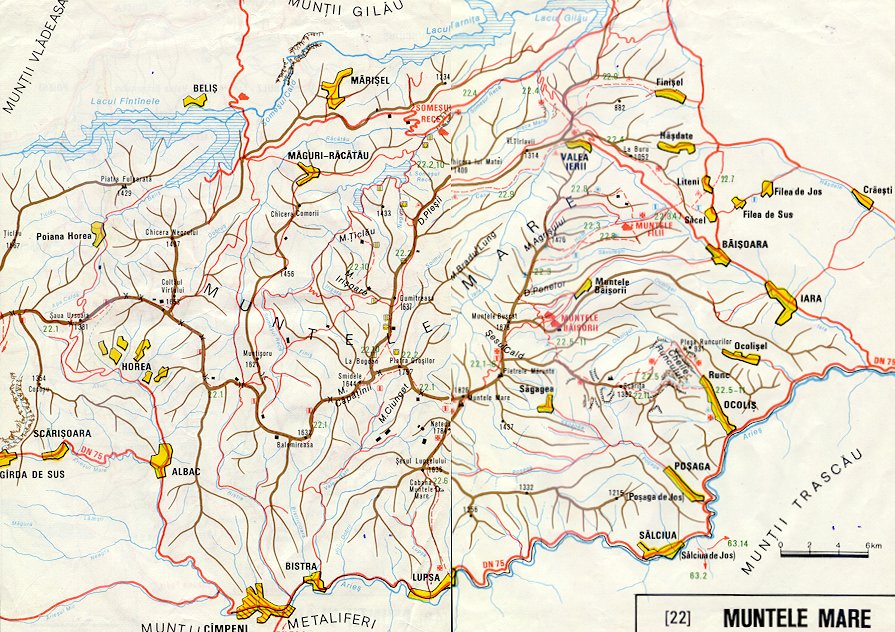
The Muntele Mare Mountains are bounded in the north and west by the Someșul Rece ( Kalter Somesch ) - a source river of the Someșul Mic ( Little Somesch ) - and the Gilăuer Mountains ( Munții Gilăului ) or the Bihor Mountains . In the east the Iara flows to the Transylvanian Basin and in the south the massif is bounded by the Arieș from the Trascau and the Transylvanian Ore Mountains ( Munții Metaliferi ).
The Muntele Mare Mountains are north of the small town of Câmpeni ( Topesdorf ) and west of Turda ( Thorenburg ); thus it belongs administratively to the north of the Alba district and to the south of the Cluj district . The highest point of the mountain is the eponymous, 1826 m above sea level. NN high peaks ( ⊙ , Muntele Mare ). The Muntele Mare peak is the third largest peak in the Transylvanian Western Carpathians , after the 1849 m high Curcubăta Mare ( ⊙ ) in the Bihor Mountains and the 1838 m high Vlădeasa in the Vlădeasa Mountains . A military unit is located on the plateau of the Muntele Mare summit .
Chlorite slate and dacite can also be found in the massif, which largely consists of limestone and metamorphic rock . Because of the gold and precious metal deposits in the Transylvanian Ore Mountains, the area was very densely populated, especially during the Roman occupation of Dacia .
In the south of the mountains there is part of the historical Motzenland .
traffic
In the south of the mountains, along the Arieș - a right tributary of the Mureș - the national road ( Drum național ) DN 75 and the small railway Turda – Abrud , which opened in 1912 and was shut down in 1998, run.
Attractions
- The nature reserves Cheile Runcului ( 46 ° 31 ' N , 23 ° 26' O ; approximately 254 ha ), Cheile Pociovaliştei ( 46 ° 30 ' N , 23 ° 25' O ) and Cheile Poşagii ( 46 ° 28 ' N , 23 ° 24 ′ E ).
- The Șesul Craiului Botanical Reserve ( Scărița-Belioara ) on a high plateau about 1350 m ( 46 ° 29 ′ N , 23 ° 22 ′ E ).
- The Izvorul Poșaga monastery and the nearby karst springs Jeredeu and Bujorul , with regular water discharge at intervals of 10 to 20 minutes in spring and every hour during drought.
- Old farms, wooden houses thatched with thatched or clapboard .
- Several wooden churches .
Significant surveys
- Piatra Groșilor 1,756 m
- Pietrele Mărunte 1,735 m
- Vârful Buscat 1,676 m
- Vârful Smidele 1,644 m
- Vârful Dumitreasa 1,638 m
- Vârful Balomireasa 1,632 m
- Vârful Muntișoru 1,621 m
Some places in the mountains and surroundings
Some important places in the region are the small town of Câmpeni ( Topesdorf ), the municipalities of Albac , Bistra , Horea , Lupşa ( Wolfsdorf ), Ocoliş , Poşaga and Vadu Moților in Alba County; the communities Băișoara (with the highest incorporated village Muntele Băișorii [ ore village ], 972-1246 m), Iara , Măguri-Răcătău , Mărișel and Valea Ierii in the Cluj district.
Some rivers in the mountains and surroundings
Some of the streams and rivers in and around the Muntele Mare Mountains are the Ampoi (Hungarian Ompoly ), Arieș (Hungarian Aranyos ), Iara , Poșaga , Sălciuța, Someșul Rece ( Kalter Somesch ), Ocoliș, Ocolișel, Valea Mare and others. v. a.
Individual evidence
- ↑ image of the military unit old and abandoned buildings; Image of the military unit newer property
- ↑ The Cheile Runcului and Cheile Pociovaliștei on www.karpatenwilli.com
- ↑ Cheile Runcului and Cheile Pociovaliștei at amfostacolo.ro ("I was there") (Romanian)
- ↑ The Cheile Poşagii and Scarita-Belioara on www.karpatenwilli.com
- ↑ Description and pictures of the Poșaga monastery (Romanian)
- ^ H. Heltmann, G. Servatius: travel guide Siebenbürgen . Kraft-Verlag Würzburg, 1993. p. 138. ISBN 3-8083-2019-2 .
- ↑ Map of the Muntele Mare Mountains