
Turda
|
Turda Thorenburg Torda |
|||||
|
|||||
| Basic data | |||||
|---|---|---|---|---|---|
| State : |
|
||||
| Historical region : | Transylvania | ||||
| Circle : | Cluj | ||||
| Coordinates : | 46 ° 34 ' N , 23 ° 47' E | ||||
| Time zone : | EET ( UTC +2) | ||||
| Height : | 330 m | ||||
| Area : | 91.43 km² | ||||
| Residents : | 47,744 (October 20, 2011) | ||||
| Population density : | 522 inhabitants per km² | ||||
| Postal code : | 401xxx | ||||
| Telephone code : | (+40) 02 64 | ||||
| License plate : | CJ | ||||
| Structure and administration (as of 2016) | |||||
| Community type : | Municipality | ||||
| Lord Mayor : | Cristian-Octavian Matei ( PSD ) | ||||
| Postal address : | Piața 1 Decembrie 1918, no. 28 loc. Turda, jud. Cluj, RO-401184 |
||||
| Website : | |||||


Turda ( German Thorenburg , Hungarian Torda ) is a town in Cluj County in Transylvania , Romania .
Geographical location and traffic

Turda is located in the west of the Transylvanian Basin, northeast of the Trascău Mountains ( Munții Trascăului ) in the historic Torda-Aranyos County . On the Arieș River - a right tributary of the Mureș ( Mieresch ) - and on the E 60 and E 81 European routes , Turda is located about 30 kilometers southeast of the district capital of Cluj-Napoca ( Klausenburg ). The Câmpia Turzii – Turda line (a branch line of the Cluj-Napoca – Războieni line ) leads to Turda and from here the narrow-gauge railway , which was closed in 1998 , continued to Abrud ( Großschlatten ) in Motzenland . For tourist purposes, the narrow-gauge railway, with a steam locomotive and two wagons, is occasionally in use for about 12 kilometers to Roșia Montană ( Goldbach ) in the Alba district .
The Romanian A3 , the so-called “Autostrada Transilvania” ( Transylvania motorway) , has also been running at Turda since around December 2010 .
history
Turda was first a settlement of the Dacians ( Potaissa ), later a Roman fortress , around which a village and later a colony formed. In the wider area, salt was mined during Roman times . Around the year 110 Emperor Trajan had a road built between Potaissa and Napoca on what is now Turda's area. The place was first mentioned in 1197. In 1278 King Ladislaus the Kumane gave the salt mines to the Weißenburg diocese (today Alba Iulia ). In the Middle Ages Turda was considered the capital of the Transylvanian county floor . Therefore it was the place of the Transylvanian general assembly of the nobility, which took place under the chairmanship of a voivode appointed by the Hungarian king from the high nobility . This assembly ( universitas nobilium ) and advisory body was responsible for the ultimate jurisdiction . At the Thorenburger Landtag in January 1568, the (restricted) religious freedom in Europe was legally established for the first time with the Edict of Torda .
The city has belonged to Romania since 1920; Hungarian and German-speaking residents are now in the minority compared to the ethnic Romanians . Today the city is an important location for the chemical and construction industries .
population
The population of the municipality developed as follows:
| census | Ethnic composition | |||||||
|---|---|---|---|---|---|---|---|---|
| year | population | Romanians | Hungary | German | other | |||
| 1850 | 8,743 | 1,861 | 6,287 | 155 | 440 | |||
| 1930 | 21,428 | 8,332 | 10,602 | 532 | 1,962 | |||
| 1966 | 44,980 | 36,544 | 7,622 | 125 | 689 | |||
| 1992 | 61,200 | 51,631 | 7.114 | 95 | 2,360 | |||
| 2002 | 55,887 | 47,442 | 5,618 | 83 | 2,744 | |||
| 2011 | 47,744 | 36,785 | 3,905 | 35 | 7,019 | |||
The highest population of today's city - and at the same time that of the Romanians - was determined in 1992. The highest population of the Magyars was registered in 1930, that of the Roma (2703) was registered in 2002 and that of the Germans (657) was registered in 1941. The Romanian population rose by leaps and bounds between 1930 and 1940 and the Hungarian population fell sharply after 1940. Furthermore, Slovaks (highest number 149 in 1930), Serbs (highest number 12 in 1930) and Ukrainians (highest number eight in 1992) were registered in almost every recording .
In 2002, eleven Italians , ten Jews , four Ukrainians, two Turks , Serbs , Slovaks , Greeks and Poles and one Lipowan , one Chinese and one Armenian were counted in Turda ; three people were registered without information.
Attractions
- The ruins of a Roman fortress, built in the 2nd or 3rd century at the place Dealul Viilor-Cetăţii , which the locals call it - next to the old salt mines - are listed as historical monuments.
- The reformed fortified church in Turda Veche ( Altthorenburg ): A single-nave Gothic church, built in the 14th century, was rebuilt inside in the Baroque style in the 18th century . In the 16th century the circular walls of the church were; 1904–1906 the 60 meter high bell tower , built, is a listed building.
- The Catholic Church, built between 1475–1504 or 1498–1504 (according to various statements), is a Gothic hall church without a tower and was also the venue for the Thorenburg State Parliament from 1568 . The church is 50 meters long, 18.20 meters wide, the altar 20.20 meters long; it is a listed building.
- The reformed church in Turda Nouă ( Neuthorenburg ), built (according to different statements) in 1504 or 1528, is a listed building.
- Today's museum of the city - the former Prince's Palace -, built in the 15th century, was rebuilt in 1560 by Prince Stephan Báthory , is a listed building.
- The former beer factory , built 1756–1814; Expanded from 1880 to 1911, are listed.
- A former monastery and Franciscan chapel, built in 1733, renovated in Baroque style from 1828–1903, is now a courthouse.
- A 1601 cm high monument - in memory of the murder of the Romanian voivod Mihai Viteazul ( Michael the Brave ) in 1601 - erected in 1977 on the place of a wooden cross from 1923 (located in the Turzeit Museum), is the work of Marius Butunoiu .
- A copy of the Capitoline Wolf ( Lupa Capitolina ), 1936 in st. Nicolae Iorga is a listed building.
- The bust of Ioan Rațiu (work by Cornel Medrea ), erected in 1930. Rațius house built in the 19th century (street Ioan Rațiu , no. 71), is a listed building.
- The Cheile Turzii ( Thorenburger Schlucht ) is about eight kilometers west of the city.
- The Turda salt mine , which has a salt dome as well as a hall several stories high, in which concerts are even performed on special occasions. In one of the chambers there is seating and an improvised playground for children, as the salty air promises relief from some respiratory diseases .

View of Turda

Mayor's office

The Catholic Church

View of the bell tower of the reformed church

The city center

The museum

The Waldorf School

The Ioan Rațiu house
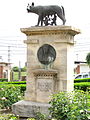
The Capitoline Wolf
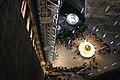
Turda Salt Mine
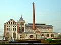
Former beer factory


Town twinning
According to the official web presentation, Turda maintains partnerships with:
-
 Angoulême in France
-
 Hódmezővásárhely and Bihartorda and Kiskunfélegyháza in Hungary
-
 Torda ( Торда ) in Serbia
-
 Szydłowiec in Poland
Sons and daughters of Turda
- Dan Anca (1947-2005), football player
- Samu von Borbely (1907–1984), Hungarian-German mathematics professor
- Adrian Borza (* 1967), composer
- Emilian Dolha (* 1979), soccer player
- Étienne Hajdú (1907–1996), French sculptor of Hungarian descent
- Miklós Jósika (1794–1865), Hungarian writer
- Baruch Kimmerling (1939–2007), Israeli sociologist
- Ioan Rațiu (1882–1902), politician (activist for Romanian national issues during the Habsburg monarchy)
- Ion Rațiu (1917–2000), politician
- Moise Vass (1920-2005), football player
See also
Web links
Individual evidence
- ↑ 2011 census in Romania ( MS Excel ; 1.3 MB)
- ↑ Dorin Ţimonea: The narrow-gauge railway back on the line in the Apuseni Mountains at historia.ro accessed on December 12, 2015 (Romanian)
- ↑ a b c d e f Heinz Heltmann, Gustav Servatius (Hrsg.): Travel Guide Siebenbürgen. Kraft-Verlag, Würzburg 1993, ISBN 3-8083-2019-2 .
- ↑ Census, last updated November 2, 2008, p. 7 (Hungarian; PDF; 1.1 MB)
- ↑ Information from the 2002 census in Turda at edrc.ro
- ↑ The Roman fortress Potaissa at visitclujnapoca.ro
- ↑ a b c d e f g h i List of historical monuments of the Romanian Ministry of Culture, updated 2010 (PDF; 7.10 MB)
- ↑ a b c d Information in the web presentation of Turda ( Memento of the original from February 4, 2015 in the Internet Archive ) Info: The archive link was inserted automatically and has not yet been checked. Please check the original and archive link according to the instructions and then remove this notice. accessed on February 4, 2015 (Romanian)
- ↑ Information on the Turda homepage ( Memento of the original from January 26, 2016 in the Internet Archive ) Info: The archive link was automatically inserted and not yet checked. Please check the original and archive link according to the instructions and then remove this notice. , accessed December 12, 2015.
Câmpia Turzii | Cluj-Napoca | Dej | Gherla | Huedin | Turda