
Bihartorda
| Bihartorda | |||||
|
|||||
| Basic data | |||||
|---|---|---|---|---|---|
| State : | Hungary | ||||
| Region : | Northern Great Plain | ||||
| County : | Hajdú-Bihar | ||||
| Small area until December 31, 2012 : | Püspökladány | ||||
| District since 1.1.2013 : | Püspökladány | ||||
| Coordinates : | 47 ° 13 ' N , 21 ° 21' E | ||||
| Area : | 22.38 km² | ||||
| Residents : | 890 (Jan. 1, 2011) | ||||
| Population density : | 40 inhabitants per km² | ||||
| Telephone code : | (+36) 54 | ||||
| Postal code : | 4174 | ||||
| KSH kódja: | 29887 | ||||
| Structure and administration (status: 2018) | |||||
| Community type : | local community | ||||
| Mayor : | vacant | ||||
| Postal address : | Kossuth Lajos út 73 4174 Bihartorda |
||||
| Website : | |||||
| (Source: A Magyar Köztársaság helységnévkönyve 2011. január 1st at Központi statisztikai hivatal ) | |||||


Bihartorda (formerly Torda ) is a Hungarian community in the county Püspökladány in Hajdú-Bihar .
geography
Bihartorda borders the following municipalities:
| Sáp | Berettyóújfalu | |
| Bihardancsháza |
.svg)
|
Bakonszeg |
| Nagyrábé |
history
First written mention in the Váradi Regestrum . The place was devastated by the Turks in 1659 and rebuilt elsewhere.
Torda (top right) around 1782 (recording sheet of the Josephinische Landesaufnahme )

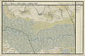
Bihar-Torda (N 47 ° 13 '; E 39 ° 2') around 1892 (recording sheet of the Franzisco-Josephinische Landesaufnahme )


Town twinning
-
 Torda (Žitište) , Serbia
 -
 Turda , Romania
Sons and daughters of the church
- Zoltán Daróczy (* 1938), Hungarian mathematician and member of the Hungarian Academy of Sciences
Attractions
- Kossuth bust ( Kossuth-mellszobor ), created in 1898 by Béla Gerenday and György Kiss
- Reformed Church, built 1793–1797 (late baroque)
- Szent István Monument ( Szent István emlékmű )
- World War Memorial ( I. és II. Világháborús emlékmű ), erected in 1959
traffic
Roads No. 4213 and No. 4805 meet in Bihartorda. The nearest train station is four kilometers north in Sáp , on the Püspökladány – Oradea railway line .
Individual evidence
- ↑ Elhunyt Bihartorda polgármestere. Borsod online, May 29, 2018, accessed July 13, 2018 (Hungarian).