
Bihardancsháza
| Bihardancsháza | |||||
|
|||||
| Basic data | |||||
|---|---|---|---|---|---|
| State : | Hungary | ||||
| Region : | Northern Great Plain | ||||
| County : | Hajdú-Bihar | ||||
| Small area until December 31, 2012 : | Püspökladány | ||||
| District since 1.1.2013 : | Püspökladány | ||||
| Coordinates : | 47 ° 14 ' N , 21 ° 19' E | ||||
| Area : | 8.31 km² | ||||
| Residents : | 185 (Jan 1, 2011) | ||||
| Population density : | 22 inhabitants per km² | ||||
| Telephone code : | (+36) 54 | ||||
| Postal code : | 4175 | ||||
| KSH kódja: | 25256 | ||||
| Structure and administration (status: 2018) | |||||
| Community type : | local community | ||||
| Mayor : | József Major (independent) | ||||
| Postal address : | Kossuth Lajos u. 17 4175 Bihardancsháza |
||||
| Website : | |||||
| (Source: A Magyar Köztársaság helységnévkönyve 2011. január 1st at Központi statisztikai hivatal ) | |||||


Bihardancsháza (formerly Dancsháza ) is a Hungarian community in the county Püspökladány in Hajdú-Bihar .
Geographical location
Bihardancsháza is 40 kilometers southwest of the city of Debrecen and borders the following municipalities:
| Sáp | ||
.svg)
|
||
| Nagyrábé | Bihartorda |
history
The first written mention goes back to the year 1384, back then as Donchhaza.
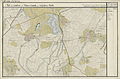
Dáncshácza (foothills, bottom right) around 1782 (recording sheet of the Josephinische Landesaufnahme )
Dancsháza (foothills top right) around 1782 (recording sheet of the Josephinische Landesaufnahme )

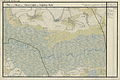
Dancsháza (N 47 ° 14 '; E 38 ° 59') around 1892 (recording sheet of the Franzisco-Josephinische Landesaufnahme )


Attractions
- Reformed Church
traffic
Road No. 4226 runs through Bihardancsháza. The nearest train station is to the northeast in Sáp.
Individual evidence
- ↑ Bihardancsháza települési választás eredményei. Országos Választási Iroda, November 18, 2014, accessed January 22, 2019 (Hungarian).