
Sárrétudvari
| Sárrétudvari | |||||
|
|||||
| Basic data | |||||
|---|---|---|---|---|---|
| State : | Hungary | ||||
| Region : | Northern Great Plain | ||||
| County : | Hajdú-Bihar | ||||
| Small area until December 31, 2012 : | Püspökladány | ||||
| Coordinates : | 47 ° 14 ' N , 21 ° 11' E | ||||
| Area : | 54.42 km² | ||||
| Residents : | 2,792 (Jan 1, 2011) | ||||
| Population density : | 51 inhabitants per km² | ||||
| Telephone code : | (+36) 54 | ||||
| Postal code : | 4171 | ||||
| KSH kódja: | 23940 | ||||
| Structure and administration (as of 2015) | |||||
| Community type : | Large community | ||||
| Mayor : | Tibor Kiss (Fidesz-KDNP) | ||||
| Postal address : | Kossuth et al. 72 4171 Sárrétudvari |
||||
| Website : | |||||
| (Source: A Magyar Köztársaság helységnévkönyve 2011. január 1st at Központi statisztikai hivatal ) | |||||


Sárrétudvari (formerly Udvárÿ) is a large municipality in the small area of Püspökladány in eastern Hungary , the place of the same name is located on the MAV Békéscsaba – Püspökladány railway between Szerep and Biharnagybajom .
geography
Sárrétudvari borders on Békés county and the following municipalities:
| Püspökladány | Báránd | |
| Szerep |
.svg)
|
|
|
Kertészsziget (BE) Füzesgyarmat (BE) |
Biharnagybajom |
history
The oldest human traces are approx. 5000 years old and can be assigned to the Kurgan culture . The place is mentioned in 1214 in the Váradi Regestrum .
Udvárÿ (bottom left) around 1782 (recording sheet of the Josephinische Landesaufnahme )

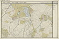
Bihar-Udvari (N 47 ° 15 '; E 38 ° 51') around 1892 (recording sheet of the Franzisco-Josephinische Landesaufnahme )


Individual evidence
- ^ Sárrétudvari települési választás eredményei ( Hungarian ) Országos Választási Iroda. November 18, 2014. Retrieved April 4, 2015.