
Tetétlen
| Tetétlen | |||||
|
|||||
| Basic data | |||||
|---|---|---|---|---|---|
| State : | Hungary | ||||
| Region : | Northern Great Plain | ||||
| County : | Hajdú-Bihar | ||||
| Small area until December 31, 2012 : | Püspökladány | ||||
| Coordinates : | 47 ° 19 ′ N , 21 ° 18 ′ E | ||||
| Area : | 32.11 km² | ||||
| Residents : | 1,376 (Jan 1, 2011) | ||||
| Population density : | 43 inhabitants per km² | ||||
| Telephone code : | (+36) 54 | ||||
| Postal code : | 4184 | ||||
| KSH kódja: | 19691 | ||||
| Structure and administration (as of 2012) | |||||
| Community type : | local community | ||||
| Mayoress : | Fülöp Hajnalka Borbélyné (independent) | ||||
| Postal address : | Kossuth et al. 65, 4184 Tetétlen |
||||
| Website : | |||||
| (Source: A Magyar Köztársaság helységnévkönyve 2011. január 1st at Központi statisztikai hivatal ) | |||||


Tetétlen is a municipality in the Püspökladány small area in eastern Hungary . The main road 42 leads through the municipality.
geography
The Keleti Canal flows through the municipality . Tetétlen borders the following municipalities:
| Kaba | Hajdúszovát | |
.svg)
|
||
| Báránd | Földes |
history
The first written mention comes from 1441.
Tetétlen (top center) around 1782 (recording sheet of the Josephinische Landesaufnahme )

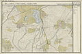
Tetétlen (N 47 ° 19 '; E 38 ° 58') around 1892 (recording sheet of the Franzisco-Josephinische Landesaufnahme )


Attractions
Individual evidence
- ↑ Tetétlen települési választás eredményei ( Hungarian ) Országos Választási Iroda. October 3, 2010. Retrieved December 13, 2011.
- ↑ www.tetetlen.hu ( Memento of the original from December 8, 2013 in the Internet Archive ) Info: The archive link was automatically inserted and not yet checked. Please check the original and archive link according to the instructions and then remove this notice. , Accessed on December 28, 2013