
Báránd
| Báránd | |||||
|
|||||
| Basic data | |||||
|---|---|---|---|---|---|
| State : | Hungary | ||||
| Region : | Northern Great Plain | ||||
| County : | Hajdú-Bihar | ||||
| Small area until December 31, 2012 : | Püspökladány | ||||
| Coordinates : | 47 ° 18 ' N , 21 ° 14' E | ||||
| Area : | 42.57 km² | ||||
| Residents : | 2,543 (Jan. 1, 2011) | ||||
| Population density : | 60 inhabitants per km² | ||||
| Telephone code : | (+36) 54 | ||||
| Postal code : | 4161 | ||||
| KSH kódja: | 26693 | ||||
| Structure and administration (as of 2012) | |||||
| Community type : | local community | ||||
| Mayor : | Miklós Kovács (independent) | ||||
| Postal address : | Kossuth tér 1 4161 Báránd |
||||
| Website : | |||||
| (Source: A Magyar Köztársaság helységnévkönyve 2011. január 1st at Központi statisztikai hivatal ) | |||||


Báránd is a municipality in the Püspökladány small area in eastern Hungary . The European route 60 runs through the town between Püspökladány and Földes .
geography
Báránd borders on the following municipalities:
| Püspökladány | Kaba | |
.svg)
|
Tetétlen | |
| Sárrétudvari |
Biharnagybajom Nagyrábé |
Földes Sáp |
Báránd (middle left) around 1782 (recording sheet of the Josephinische Landesaufnahme )

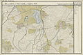
Báránd (N 47 ° 17 '; E 38 ° 53') around 1892 (recording sheet of the Franzisco-Josephinische Landesaufnahme )


traffic
The European route 60 runs through Báránd at this point as the Hungarian main route 42 , as does the Püspökladány – Oradea railway .
Partnerships
-
 Ștefănești (Mureș) in Mureș County (Romania)
 -
Pava in Covasna County (Romania)
Personalities
- Iván Balassa (1917–2002), Hungarian ethnographer