
Muriwai Beach
| Muriwai Beach | ||
| Geographical location | ||
|
||
| Coordinates | 36 ° 50 ′ S , 174 ° 26 ′ E | |
| Region ISO | NZ-AUK | |
| Country |
|
|
| region | Auckland | |
| District | Auckland Council | |
| Ward | Rodney Ward | |
| Residents | few | |
| height | 100 m | |
| Post Code | 0881 | |
| Telephone code | +64 (0) 9 | |
| Photography of the place | ||
 Muriwai Beach |
||
| Remarks | ||
| until October 2010 for Rodney District belonging | ||


Muriwai Beach is a settlement in the Auckland Council urban areaon the west coast of the North Island of New Zealand . The settlement was until November 1, 2010 when it was incorporated into the Rodney District .
Origin of name
Muriwai can be composed of the terms “ muri ” for end and “ wai ” for water.
geography
Muriwai Beach is located around 29 km west of downtown Auckland on the west coast of the Northland Peninsula . The settlement forms the end of an approximately 50 km long beach that extends from the mouth of Kaipara Harbor to Muriwai Beach and is also called Muriwai Beach towards the settlement . It is around 24 km to the entrance to Manukau Harbor in the south-east.
geology
Sand and rocks are of volcanic origin, which form cliffs with many concretions and layers. There is a blowhole in one of the rocks that throws water upwards when the surf is good. The coast is known for its black, ferruginous sand. This comes from the weathering of old volcanoes in the area. This black material is carried up the west coast by the currents from the south.
tourism
As one of several popular resorts in the region, such as Piha and Karekare , the settlement's beach is mostly frequented by Auckland holidaymakers.
Sports
Along with swimming, surfing is one of the most popular beach activities. There are also parasailing and hang-gliding , for which the prevailing westerly wind often offers good conditions. Sand yachts are rented on the coast. Fishing is also popular, but dangerous in many places because of the strong surf. Excursions into the adjacent bush are made easier by plank paths. For mountain bikers there are routes in the pine forest of the hinterland, especially downhill and freeride routes.
nature
The Māori Bay in the south is from Muriwai Beach separated by steep cliffs and rocks. Here is the only colony of Australian gannets , called Takapu in Māori , in the region. Much of the area at the south end of the beach is part of the Muriwai Beach Regional Park .
Photo gallery
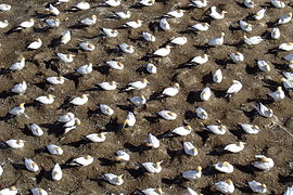
Nesting boobies
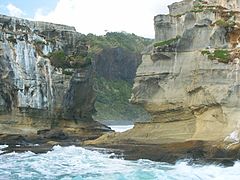
Gannet Colony, Māori Bay in the background

' Muriwai Energy ' dangerous surf on the flat rocks

"Extreme fishing" near Muriwai
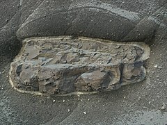
Concretion - a marine fossil

Blowhole


literature
- Helga Neubauer: Muriwai Beach . In: The New Zealand Book . 1st edition. NZ Visitor Publications , Nelson 2003, ISBN 1-877339-00-8 , pp. 191 f .