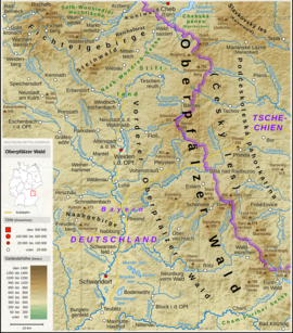
Naab Mountains
| Naab Mountains | |
|---|---|
|
Upper Palatinate Forest |
|
| Highest peak | Rotbühl ( 673 m above sea level ) |
| location | Upper Palatinate , Bavaria , Germany |
| Part of | Upper Palatinate Forest |
| Coordinates | 49 ° 29 ′ N , 12 ° 1 ′ E |
The Naab Mountains , also called Naabbergland , are the westernmost foothills of the Upper Palatinate Forest . The Naabgebirge is a crystalline spur of the Moldanubic , which protrudes from the Upper Palatinate Forest over the Naab to the west into the Upper Palatinate hill country .
Natural allocation and structure
Since of the individual sheets 1: 200,000 for the manual of the natural spatial structure of Germany only sheet 164 Regensburg was published, but not sheet 154/155 Bayreuth , there is only a detailed breakdown for the southern part of the landscape.
The following sub-landscapes are shown:
-
(to 401 Vorderer Oberpfälzer Wald )
-
(to 401.3 Southwest Lower Upper Palatinate Forest)
-
401.39 Naab Mountains
- 401.391 Eastern Naab Mountains
- 401.392 Western Naab Mountains
- 401.393 Rottendorfer Bay
-
401.39 Naab Mountains
-
(to 401.3 Southwest Lower Upper Palatinate Forest)
geography
The Naab Mountains are the westernmost part of the Upper Palatinate Forest and thus also the westernmost part of the Bohemian Massif, which includes the Upper Palatinate Forest, the Bohemian Forest and the Bavarian Forest . In the east the Naab Mountains are bordered by the Naab Valley , in the north by the Hirschau-Schnaittenbacher Senke and in the south by the Pennading-Schmidgaden-Stulln-Weidinger Graben .
geology
From a geological point of view, the Naab Mountains consist of various coarse-grained and fine-lenticular biotite, cordierite and sillimanite gneisses , which are broken through from southwest to northeast or from west to east trending granite intrusions . It is noticeable that fine-grain granite predominates in the north up to a line between Freudenberg and north of Nabburg , while the southern flank of the Naab Mountains is made up of medium to coarse-grain granite and the Stulln area is ultimately made up of reddish Wölsendorfer granite.
mountains
The highest mountains of the Naab Mountains are - sorted according to height in meters (m)
above sea level (NN) as well as with municipalities and position link according to geo-coordinates :
- Rotbühl , 673 m , Schnaittenbach ( ⊙ )
- Buchberg , 667 m , Schnaittenbach ( ⊙ )
- Siegelberg , 658 m , Freudenberg ( ⊙ )
- Blässelberg , 656 m , Freudenberg ( ⊙ )
- Hirmerberg , 652 m , Freudenberg ( ⊙ )
- Friedrichsberg , 631 m , Freudenberg ( ⊙ )
- Kulm , 626 m , Nabburg ( ⊙ )
- Johannisberg , 604 m , Freudenberg ( ⊙ )
- Blauberg , 572 m , Freudenberg ( ⊙ )
Important localities
literature
- Dietrich-Jürgen Manske : Geographical land survey. The natural space units on sheet 164 Regensburg. Federal Institute for Regional Studies, Bad Godesberg 1981. → Map (PDF; 4.8 MB, 1983 edition).
Web links
- Literature on the Naab Mountains in the catalog of the German National Library
- Basement Mountains (Pre-Permian) - Distribution and Depth. (PDF; 2.01 MB) on stmwi.bayern.de
Individual evidence
- ^ Emil Meynen , Josef Schmithüsen (editor): Handbook of the natural spatial structure of Germany . Federal Institute for Regional Studies, Remagen / Bad Godesberg 1953–1962 (9 deliveries in 8 books, updated map 1: 1,000,000 with main units 1960).
- ↑ a b c Dietrich-Jürgen Manske (Hrsg.): Geographische Landesaufnahme. The natural space units on sheet 164 Regensburg . Federal Research Center for Regional Studies and Regional Planning, Bonn / Bad Godesberg 1983, ISBN 3-87994-355-9 , p. 53–54 ( geographie.giersbeck.de [PDF; 4.8 MB ] only card online).
- ↑ Martin Mehringer: Geological walks in the Amberger Land . Amberg 1996, p. 7 .
