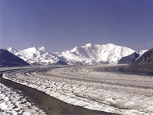
Nabesna glacier
| Nabesna glacier | ||
|---|---|---|
|
Nabesna Glacier with Mount Blackburn (right) and Atna Peaks (twin peaks left) in the background |
||
| location | Alaska ( USA ) | |
| Mountains | Wrangell Mountains | |
| Type | Valley glacier | |
| length | 80 km | |
| Exposure | North | |
| Altitude range | 3300 m - 900 m | |
| width | ⌀ 4.5 km | |
| Coordinates | 61 ° 56 ′ N , 143 ° 5 ′ W | |
|
|
||
| drainage | Nabesna River | |
The Nabesna Glacier is a glacier in Wrangell-St Elias National Park in the Wrangell Mountains in southeastern Alaska .
With a length of 80 km, it is one of the longest valley glaciers on earth that does not flow into a sea.
The glacier flows from the eastern flank of the 4,317 m high Mount Wrangell first eastwards past Mount Blackburn and the Atna Peaks , then turns north and ends in a valley about 25 km south of the old mining settlement of Nabesna . Around 40 glaciers from side valleys feed the Nabesna. Its meltwater forms the Nabesna River , which flows through the Tetlin National Wildlife Refuge to the Tanana River .
The glacier was named in 1902 by FC Schrader of the United States Geological Survey after the river that rises from it.

