Wet (leash)
| Wet | ||
|
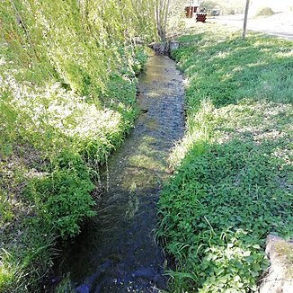
Lower course of the Nasse in Wickerode in April 2019 |
||
| Data | ||
| location | Germany , Saxony-Anhalt , district of Mansfeld-Südharz , municipality of Südharz | |
| River system | Elbe | |
| Drain over | Leine → Helme → Unstrut → Saale → Elbe → North Sea | |
| source | south of Rotha in the Harz Mountains | |
| Source height | approx. 433 m | |
| muzzle | south of Wickerode in the Leine Coordinates: 51 ° 28 ′ 13 ″ N , 11 ° 7 ′ 54 ″ E 51 ° 28 ′ 13 ″ N , 11 ° 7 ′ 54 ″ E |
|
| Mouth height | approx. 155 m | |
| Height difference | approx. 278 m | |
| Bottom slope | approx. 30 ‰ | |
| length | 9.3 km | |
| Communities | South Harz | |
The Nasse is a 9.3 km long right tributary of the Leine in the southeastern Harz, in the district of Mansfeld-Südharz , in Saxony-Anhalt .
course
The stream rises south of the village of Rotha in the Harz Mountains, which belongs to the district town of Sangerhausen . After a good 2.3 km of flow, the Nasse changes its main direction of flow from west to south. The first village in the middle Nassetal is Questenberg . Further downstream follows Wickerode , both of which belong to the southern Harz community . Only about 400 m south of Wickerode the Nasse flows into the Leine flowing in from the east .
Upper course of the Nasse in Questenberg
Web links
Commons : Nasse - collection of images, videos and audio files
Individual evidence
- ↑ Map from Google Earth


