
Canaima National Park
| Canaima National Park | |||
|---|---|---|---|
 |
|||
|
|||
| Location: | Bolívar , Venezuela | ||
| Surface: | 30,000 km² | ||
| Founding: | June 12, 1962 | ||
 |
|||

The Canaima National Park (Spanish Parque Nacional Canaima ) is located in the Gran Sabana , in the state of Bolívar in the southeast of Venezuela .
history
The government of Venezuela founded the national park on June 12, 1962. It initially covered an area of 10,000 km². In 1975 the park was expanded to a total area of 30,000 km², making it one of the largest national parks in the world. It borders Brazil and Guyana to the south . The Canaima National Park is one of six national parks in the Amazon region. The UNESCO declared it in 1994 for World Natural Heritage .
During the supply crisis in Venezuela from 2015, most of the tourists stayed away. Contrary to their custom of respect for their environment, the inhabitants, often members of the indigenous people of the Pemón , began to dig for gold in illegal mines within the national park.
landscape
The Gran Sabana area, in the Guayana Mountains , is a highland rugged by valleys. Characteristic of the National Park are powerful table mountains of sandstone , the tepuis are called and cover about 65% of the park. A unique flora and fauna has developed on their high plateaus. Due to the climatic isolation of the high plateaus from the tropical rainforest , evolution in isolation over millions of years has produced a large number of endemic species . Some of the highest waterfalls in the world such as the Salto Ángel or the Salto Kukenan plunge down from the table mountains. They are a special attraction for tourism.
fauna
The Canaima National Park has a varied fauna, which is distributed in the park according to various environmental factors such as height and vegetation type. The number of species is divided into: 118 mammals, 550 birds, 72 reptiles and 55 amphibians. Among the species found are:
- Giant armadillo ( Priodontes maximus )
- Giant otter ( Pteronura brasiliensis )
- Giant anteater ( Myrmecophaga tridactyla )
- Puma ( Puma concolor )
- Jaguar ( Panthera onca )
- Actual two- toed sloth ( Choloepus didactylus )
- Bald Saki ( Pithecia pithecia )
- Brown-backed kaki ( Chiropotes israelita )
- Roraima mouse ( Podoxymys roraimae )
- Tepui pygmy pouch rat ( Marmosa tyleriana )
- Harpy eagle ( Harpia harpyja )
- Blue-fronted Macaw ( Diopsittaca nobilis )
- Violet Parrot ( Pionus fuscus )
- Yellow-banded tree climber ( Dendrobates leucomelas )
- Green iguana ( Iguana iguana )
- Hummingbirds (Trochilinae)
- Toucans (Ramphastidae).
- South American Bushmaster ( Lachesis muta )
flora
Canaima National Park contains an estimated 3000-5000 species of phanerogams and ferns. The tepui system (which includes all tepui formations and is known as pantepui) contains a high proportion of endemic taxa. For example, 900 species of higher plants have been identified from the Auyán Tepui, of which about 10% are endemic to this massif. Canaima is also famous for its variety of orchids, with an estimated 500 species in the national park.
There are over 300 endemic species only in the Gran Sabana :
- Endemic genera: Achnopogon , Chimantaea , Quelchia , Tepuia , Mallophyton , Adenanthe .
- Common insectivorous species from the genera: Bromelia , Drosera , Heliamphora , Utricularia .
Hydrography
The national park covers the entire watershed of the right bank of the Caroní River and two of the highest waterfalls in the world, the Angel Falls and the Kukenán, as well as numerous waterfalls at lower elevations.
Tourist attractions
Western area
|
|
Eastern area
|
|
gallery

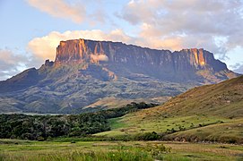
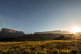
View of the Tepuis Kukenán and Roraima in the Gran Sabana .
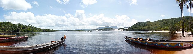
Panoramic view of the Canaima lagoon
Kukenan sunset

Mount Roraima
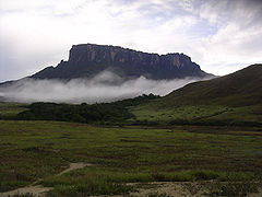
Kukenan Tepui

Tepuis in Canaima
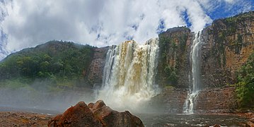
Chinak-Meru
Roraima tepui in the Guiana Highlands

Kamá waterfall

Canaima waterfall

Kukenan
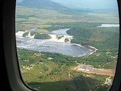
View from the arriving aircraft of the Canaima lagoon, Saltos Golondrina, Saltos Ucaima and the runway


.jpg)


.jpg)


Web links
- Entry on the UNESCO World Heritage Center website ( English and French ).
- Canaima National Park on biolib.cz (English)
- Protected Planet Page for Canaima
Individual evidence
- ^ Canaima National Park. WWF , accessed July 14, 2016 .
- ↑ Living Amazon Report 2016. (PDF) WWF, p. 81 , accessed on July 14, 2016 (English).
- ↑ Quiénes son los pemones y cómo viven en rebeldía contra el gobierno de Nicolás Maduro en una de las zonas más remotas de Venezuela , BBC, 4th January 2019
- ^ The World's Highest Free-Falling Waterfall. In: WWF. Retrieved July 14, 2016 .
- ↑ https://archive.is/19970710092822/http://www.wcmc.org.uk/protected_areas/data/wh/canaima.html UNEP World Conservation Monitoring Center
- ^ Government of Venezuela (1993). World Heritage List Nomination: Canaima National Park, Venezuela. 53pp. + Maps and Annexes.
- ↑ https://archive.is/19970710092822/http://www.wcmc.org.uk/protected_areas/data/wh/canaima.html UNEP World Conservation Monitoring Center

Heritage: old town and port of Coro (1993, R ) | University City of Caracas (2000)
Natural heritage: Canaima National Park (1994)