Serra do Cipó National Park
| Serra do Cipó National Park | ||
|---|---|---|
| map | ||
|
||
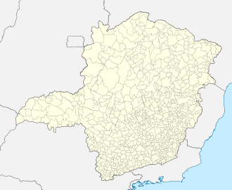
The Serra do Cipó National Park is a national park in the state of Minas Gerais in Brazil that has existed since 1984 and has a size of 31,010 hectares.
An entrance to the park is about 90 km northeast of the capital Belo Horizonte on the state road MG-010 on the border between the municipalities of Jaboticatubas and Santana do Riacho, marked by the Rio Cipó . The national park is part of the Serra do Espinhaço. The flora is dominated by the grass and shrub areas, the Campos de Altitude. However, you can also find orchids , bromeliads and cacti .
The fauna contains some endemic species such as the green-masked hummingbird ( Augastes scutatus ), but also marsh deer ( Blastoceros dichotomus ), ocelots and anteaters . The skin of the pajama frog ( Hyla cipoensis ) (Brazilian: Sapo de pijama) contains a deadly secretion.
Several waterfalls such as the Cachoeira de Farofa and the Canyon das Bandeirantes can be hiked. In the park there are prehistoric rock carvings from around 12,000 BC in several places , which, in addition to anthropomorphic representations, also show the bodies of three -toed and two-toed sloths in rusty red color. Guided tours take place with the local rangers .
literature
- Rolf Grantsau : The rediscovery of the Brazilian hummingbirds Augastes scutatus and Augastes lumachellus , Journal of Ornithology, Volume 109, Number 4, 1968, pp. 434–437
Web links
- Photo gallery of the Serra do Cipó National Park on pbase.com
- Parque Nacional Serra do Cipó
- Altamira - Gate to the Serra do Cipó Project to protect a unique natural paradise
- Descubra a Serra do Cipó , (Portuguese)


