Natterwand
| Natterwand | ||
|---|---|---|
|
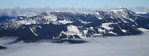
Natterwand (right in the foreground) in front of the Blauberge |
||
| height | 1618 m above sea level A. | |
| location | Tyrol , Austria | |
| Mountains | Brandenberg Alps | |
| Dominance | 1.7 km → Blauberge | |
| Notch height | 332 m ↓ in the saddle | |
| Coordinates | 47 ° 34 '20 " N , 11 ° 44' 58" E | |
|
|
||
| rock | Oberrhätkalk | |
| Age of the rock | Upper Rhaetium | |
The Natterwand is a 1618 m above sea level. A. high mountain in the Brandenberger Alps in Tyrol .
topography
The mountain is the highest peak in the heavily forested mountain group between Schneidjoch in the east and the Achental . The group is separated from the Blue Mountains, which already belong to the Bavarian Prealps , by the Klammbachtal and the Satteltal, and before the Alpine Club division of the Eastern Alps in 1984, it was itself assigned to the Bavarian Prealps. Other peaks in the small group are the Rotmöserkopf ( 1522 m ), the Mahmooskopf ( 1336 m ) and the somewhat isolated Hofjoch ( 1341 m ) in the west.
rise
The Natterwand, which has had a summit cross since 2003 and has a steep north face, is praised for its view of the Blauberge, Schneidjoch, Guffert and Unnütze . It is climbed from the Achental on a partially marked path in two and a half to three hours via the Festlalm-Niederleger (which can also be reached from the road to Steinberg am Rofan ) and the Festlalm-Hochleger.
literature
- W. and G. Zimmermann: Alpine Club Leader Bayerische Voralpen Ost , 2nd edition, Bergverlag Rudolf Rother, Munich 1980, ISBN 3-7633-1103-3
- Federal Office for Metrology and Surveying: Austrian Map 1: 50000 Sheet 88 Achenwald

