
Nederlek
 flag |
 coat of arms |
| province |
|
| local community | Krimpenerwaard |
|
Area - land - water |
31.24 km 2 27.77 km 2 3.47 km 2 |
| Residents | 14,143 (Dec. 31, 2014) |
| Coordinates | 51 ° 54 ′ N , 4 ° 39 ′ E |
| Important traffic route |
|
| prefix | 0180 |
| Postcodes | 2861, 2871, 2921, 2923, 2925, 2931, 2935, 2941 |
 |
|
Nederlek ( ) was a municipality in the Dutch province of Zuid-Holland and, according to the CBS, had 14,143 inhabitants on December 31, 2014 . The total area of the municipality was 31.24 km². On January 1, 2015, it was incorporated into the municipality of Krimpenerwaard .
places
The community consisted of the two typically Dutch villages Krimpen aan de Lek (= Krimp [curve] on the Lek) and Lekkerkerk (= church on the Lek), where the municipal administration is located.
Location and economy
The community was a bit isolated east of Rotterdam in the polder Krimpenerwaard on the river arms Lek (on the east side) and Noord (to the west). The two villages have always lived from agriculture and river navigation. In the meantime there is also some industry, and commuters have settled here who drive to their jobs every day in Rotterdam and the surrounding area, which is only about 12 km away.
history
The two villages emerged in the Middle Ages when the moors between the Dutch river arms began to be polded. The St. Elisabeth flood of 1421 temporarily destroyed many things, but they persevered. During the Eighty Years' War in 1575/1576, the area was temporarily Spanish, but was soon liberated by the Dutch. From 1620 to 1668 a farmer is said to have lived in Lekkerkerk who was 2.59 meters long and weighed 250 kilograms. He was killed in an argument at the fair. Krimpen aan de Lek was a whaling center from 1714 to 1742 .
In 1980, Lekkerkerk was the first place in the Netherlands where the soil under a newly built residential area had to be dug up and replaced. Soil heavily contaminated with chemical waste had been used for the construction of the residential area. This toxic waste scandal caused a stir across the country.
Attractions
The rural surroundings especially attract bird lovers . Among other things, the former Bakkerswaal duck cage and the Kleine Zaag river island are ideal for bird-watching. Nice bike rides are also possible over the narrow dykes and farm paths.
photos
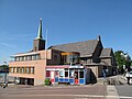
Krimpen ad Lek, church

Krimpen ad Lek, water tower

Krimpen ad Lek, one street

Lekkerkerk, church: Grote of Johanneskerk


politics
Distribution of seats in the municipal council
| Political party | Seats | |||
|---|---|---|---|---|
| 1998 | 2002 | 2006 | 2010 | |
| VVD | 4th | 3 | 3 | 4th |
| PvdA | 4th | 4th | 5 | 4th |
| Werkgroep '84 | 2 | 2 | 2 | 3 |
| CDA | 2 | 3 | 3 | 2 |
| SGP | 2 | 2 | 2 | 2 |
| D66 | 1 | 1 | 0 | - |
| total | 15th | 15th | 15th | 15th |
sons and daughters of the town
- Marjolein de Jong (* 1968), volleyball player
- Yvonne van Vlerken (* 1978), triathlete
Web links
Individual evidence
- ↑ a b Bevolkingsontwikkeling; regio per maand Centraal Bureau voor de Statistiek , accessed on June 2, 2018 (Dutch)
- ↑ Illustration by Frans Hogenberg from 1576: A fortress was Krimpen gnant, Wolt didn’t give himself up to Princen hant, Darumb ers attacked with violence, ... ( digital copy )
- ↑ Allocation of seats in the municipal council: 1998–2002 2006 2010 , accessed on June 2, 2018 (Dutch)