
Neelagunda
| Neelagunda ನೀಲಗುಂದ |
|||
|---|---|---|---|
|
|||
| State : |
|
||
| State : | Karnataka | ||
| District : | Go away | ||
| Sub-district : | Harapanahalli | ||
| Location : | 14 ° 44 ' N , 75 ° 54' E | ||
| Height : | 600 m | ||
| Area : | 13.4 km² | ||
| Residents : | 3,805 (2011) | ||
| Population density : | 284 inhabitants / km² | ||
.jpg) |
|||

Neelagunda or Nilagunda ( Kannada : ನೀಲಗುಂದ) is a village with approx. 4,000 inhabitants in the parish ( taluk ) of Harapanahalli in the Davanagere district in the southwest Indian state of Karnataka . The place has an interesting medieval temple.
location
Neelagunda is located near the geographical center of Karnataka at an altitude of approx. 600 m ; the district capital Davanagere is about 40 km (driving distance) south. Because of the altitude, the climate is rather moderate by Indian standards; Rain (approx. 640 mm / year) falls mainly during the monsoon months May to October.
population
Approx. 85% of the majority Kannada- speaking population are Hindus and about 13% are Muslim ; other religions ( Jains , Sikhs , Buddhists , Christians etc.) form numerically small minorities. The male population is about 5% higher than the female.
economy
The inhabitants of Neelagunda mainly live as farmers, artisans, small traders and small service providers or day laborers . Mainly wheat , lentils and chickpeas are grown in the fields in the area , but coconut palms also play an important role in the economic life of the region.
history
A medieval inscription from 1087 mentions a Brahmin settlement ( agraharam ) called Nirgunda ; at that time it belonged to the Chalukya and later to the Hoysala empire. In the 15th and first half of the 16th century, the area was part of the Vijayanagar Empire, in 1690 it came under the control of the princely state of Mysore , whose rule, however, in the second half of the 18th century by Hyder Ali (r . 1761–1782) and his son Tipu Sultan (r. 1782–1799) was interrupted. After that, the British played the dominant military and economic role in South India until independence (1947).
Attractions

- Despite the inscription from the year 1087, located near the Bhimeshwara temple dedicated to the Hindu god Shiva , the date of foundation, the founder (s) and the further history of the temple are unclear. The Archaeological Survey of India sees it as a building from the late Chalukya period (11th century), but many details indicate that it was built or reconstructed in the Hoysala period (13th century). It is one of the shamrock-shaped temples of Karnataka, but only above the cella ( garbhagriha ) in the west rises a multi-tiered tower ( vimana ) with a "umbrella dome" and a vase ( kalasha ) ; the side towers were never completed or have disappeared. Between the cellae there is a vestibule ( mandapa ) with carved columns and a reclining Nandi bull on a pedestal. While the outside of the temple is largely unadorned, the inside features the turned soapstone columns that are typical for Chalukya architecture and later also for Hoysala architecture ; a diverse rose decoration in the ceiling compartments and an exceptionally richly designed entrance portal to the cella, in which a Shiva lingam is located. The temple was built at ground level, but rests on a 80 cm high base zone to protect against ( monsoon ) rain and animals roaming free; a ritual transformation ( pradakshina ) is therefore only possible on the floor level covered with stone slabs.
- Several medieval inscription steles were placed directly next to the temple.

Detail of the tower structure
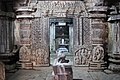
Vestibule ( mandapa ) with portal to the cella

Glance into the vestibule
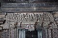
stone lintel beam with Shiva, Parvati and numerous servants; including a gajalakshmi motif

Shiva and Parvati


literature
- Channabasappa S. Patil: Temples of Raichur and Bellary Districts. Directorate of Archeology and Museums, Mysore 1992.
- Channabasappa S. Patil: Inscriptions of Bellary District. Directorate of Archeology and Museums, Mysore 1997.
Web links
- Neelagunda, Bhimeshwara Temple (Wikipedia, English)
- Neelagunda, Bhimeshwara Temple - Photos + Info (English)