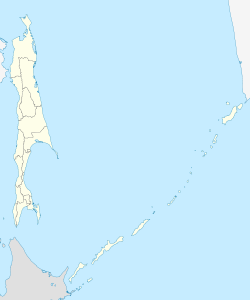
Neftegorsk (Sakhalin)
| Former settlement
Neftegorsk
Нефтегорск
|
||||||||||||||||||||
|
||||||||||||||||||||
|
||||||||||||||||||||
Neftegorsk ( Russian Нефтегорск ) was an urban-type settlement in the Russian Sakhalin Oblast , in 1995 by an earthquake completely destroyed and abandoned.
geography
The settlement was in the north of Sakhalin , about 25 km from the east coast of the island to the Sea of Okhotsk and a good 10 km from the lagoon lake Piltun, on the river Kadylanji. It was located almost 700 km as the crow flies north of the Yuzhno-Sakhalinsk Oblast Administrative Center and almost 70 km south of the city of Ocha , to whose urban district (formerly Rajon ) the territory belongs today.
The regional road 64N-1, which connects Yuzhno-Sakhalinsk via Poronaisk with Ocha, passes to the west of the village .
history
The place was founded in 1964 as a settlement for oil workers under the name Vostok (Russian "East") in place of an existing temporary workers' settlement. In 1970 the status of an urban-type settlement was given, with simultaneous renaming in Neftegorsk (from Russian neft for petroleum ). Around 1970, 17 five-storey prefabricated buildings were built and a branch line was brought up from the main line of the narrow-gauge railway Nogliki - Ocha (in operation 1953-2006), which ran further east .
On May 28, 1995 at 01:04 local time (May 27 13:03:52 UTC ) was the north of Sakhalin by a severe earthquake of magnitude 7.1 M wb on the moment magnitude scale , or 7.6 M S shaken on the surface wave magnitude scale . The epicenter was 40 km south-southwest of Neftegorsk, the depth of the earthquake was 11 km. In Neftegorsk, the quake completely destroyed the non-earthquake-proof prefabricated houses in which almost all residents were staying at the time, in contrast to some of the mainly public buildings that were built in other designs. 2040 of the 3200 inhabitants at the time were killed and 720 injured. This was one of the most momentous earthquakes on today's territory of Russia; only in a quake not far from the Kuril Islands with the following tsunamis in 1952 there were more victims.
After the quake it was decided not to rebuild the settlement. Most of the remaining residents were resettled to Yuzhno-Sakhalinsk, Ocha and Nogliki, some of them also to the mainland. Not far from the cemetery where the victims are buried, there is now a memorial and a chapel.
Population development
| year | Residents |
|---|---|
| 1979 | 3974 |
| 1989 | 3507 |
| 1995 | 0 |
Note : 1979 and 1989 census data
Picture gallery
Individual evidence
- ↑ a b M 7.1 - Sakhalin, Russia, 1995-05-27, 13:03:52 (UTC), 52.629 ° N 142.827 ° E, 11.0 km depth. In: Earthquake Hazards Program. USGS , accessed November 12, 2019 .
- ↑ The 27 May 1995 Ms 7.6 Northern Sakhalin Earthquake: An Earthquake on an Uncertain Plate Boundary in the Bulletin of the Seismological Society of America. February 2004, pp. 117–130 (English)
- ↑ Information on the location and the earthquake at RIA Novosti , May 28, 2010 (Russian)
- ↑ Archive images (video) at RIA Novosti (Russian)


