Nepomuk Bridge (Pleinfeld)
Coordinates: 49 ° 6 ′ 17 ″ N , 10 ° 59 ′ 14 ″ E
| Nepomuk Bridge | ||
|---|---|---|
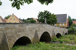
| The south side of the Nepomuk Bridge | ||
| use | Road traffic, foot traffic | |
| Crossing of | Swabian Rezat | |
| place | Pleinfeld | |
| Entertained by | Market Pleinfeld | |
| construction | Arch bridge | |
| overall length | 33 meters | |
| width | 7.5 meters | |
| opening | 1695 | |
| location | ||
|
|
||
| Above sea level | 372 m above sea level NHN | |
The Nepomuk Bridge (also Rezat Bridge ) is a stone and arch bridge that crosses the Swabian Rezat in Pleinfeld , a market in the Weißenburg-Gunzenhausen district in Central Franconia . The building is registered under the monument number D-5-77-161-45 as an architectural monument in the Bavarian monument list. It is the only river crossing within Pleinfeld that is accessible by car.
The Nepomuk Bridge was built over a ford in the east of the Pleinfeld town center at a height of 372 meters above sea level . The Brückenstraße running over the bridge is an eastward extension of the Pleinfeld market square . The structure has a length of 33 meters.
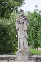
The bridge, made of sandstone blocks , dates back to 1695 and was built during the economic boom of the town after the Thirty Years' War . After the bridge was attempted to be blown up on April 22, 1945, it was badly damaged and was renewed in 1949. The bridge figure of St. John Nepomuk , who gave the bridge its name, in the middle of the bridge on the south side, dates from the 18th century. There is a metal cross on the opposite side . The bridge was renovated in 1995 and from March to the end of May 2017. Until 1995 there was a hollow in front of the bridge in order to divert the water of the Swabian Rezat during floods.
The Arbach flows into the Swabian Rezat near the bridge .
literature
- Gotthard Kießling: Weissenburg-Gunzenhausen district (= Bavarian State Office for Monument Preservation [Hrsg.]: Monuments in Bavaria . Volume V.70 / 1 ). Karl M. Lipp Verlag, Munich 2000, ISBN 3-87490-581-0 .
Web links
Individual evidence
- ↑ Bridge ( page no longer available , search in web archives ) Info: The link was automatically marked as defective. Please check the link according to the instructions and then remove this notice. on the list of monuments of the Bavarian State Office for Monument Preservation
- ↑ Topographic maps , Bavarian Surveying Office ( BayernAtlas )
- ↑ Determined with the help of the BayernAtlas
- ^ History . Markt Pleinfeld (accessed March 8, 2017)
- ^ Josef Lidl : Churches and chapels in and around Pleinfeld. Gunzenhausen 1987. p. 12.
- ^ Franz Xaver Buchner : The Diocese of Eichstätt, historical-statistical description, based on the literature, the registry of the Episcopal Ordinariate Eichstätt and the parish reports , Vol .: 2, Eichstätt, (1938), p. 399.


