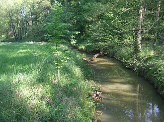
Neugraben (Black Magpie)
|
New dig Anna Canal |
||
|
The Neugraben in the Annaburg Heath |
||
| Data | ||
| location | Brandenburg and Saxony-Anhalt , Germany | |
| River system | Elbe | |
| Drain over | Black Elster → Elbe → North Sea | |
| origin | Junction from the Schwarzen Elster near Neumühl 51 ° 34 ′ 12 ″ N , 13 ° 21 ′ 18 ″ E |
|
| Source height | 83 m above sea level NN | |
| muzzle | at Grabo in the Schwarze Elster Coordinates: 51 ° 47 ′ 16 ″ N , 12 ° 55 ′ 10 ″ E 51 ° 47 ′ 16 ″ N , 12 ° 55 ′ 10 ″ E |
|
| Mouth height | 71 m above sea level NN | |
| Height difference | 12 m | |
| Bottom slope | 0.4 ‰ | |
| length | 30 km | |
| Catchment area | 306 km² | |
The Neugraben is an artificially created water channel that was created in 1576/77 on the orders of Elector August of Saxony . It leads from the Schwarzen Elster near Neumühl to the then newly built Annaburg and flows back into the Schwarze Elster near Grabo. The builders of the trench were Christof Tendler and the Saxon chief miner Martin Planer from Freiberg . The financial regulations of the building were made by the rent master Barthel Lauterbach , who was also responsible for the creation of many inheritance books in the Electorate of Saxony .
history
On July 26, 1576, the construction of the new trench started just behind the village of Grabo. A connection to the Black Elster was also established near Neumühl . The canal, which at that time was still called the new ditch , was supposed to bring the water of the Black Elster into the castle ditches of Lochau , but also to drain the surrounding area. At the same time, it should be possible to transport wood from the densely wooded Annaburg Heath with rafts. Around 2,300 men from the surrounding offices were forcibly used by the elector to labor for the construction. According to the construction contract at the time, the trench should be 14 cubits wide at the top and 6 cubits at the bottom . It was also determined that an elevation with a width of one cubit should be created on each side. With the construction of the new trench, the construction of an electoral official mill in Annaburg was also planned. On October 13, 1577, Martin Planer was able to report the completion of the canal to the Elector. Until 1780, the canal was used as a shipping and raft route. In 1834 a swimming pool was excavated at Neugraben on the old Herzberger Strasse by the Annaburg Military Boys' Educational Institute and used until the facility was closed in 1921. The pool is around 100 meters long, 20 meters wide and between 1 and 2.50 meters deep. The side walls were covered with oak boards. The connection to the ditch also made it possible to simulate swimming in the current. The swimming pool can still be seen today. In the 1930s, the canal was cleared of silt by the Reich Labor Service and the course, which was overgrown in places, was cleaned, and the banks were partially plaited with new fascines. In addition, the trench was dug deeper, and strong obstructive curves were removed, so that the trench received a greater flow velocity. The Neugraben is a technical monument under monument protection .
bridges
In the Annaburg Heath, the Neugraben passes under ten navigable bridges over a distance of around 10 kilometers, which were named as follows after their construction: Torgauer Bridge, Zätsch Bridge, Rotten Bridge, Bank Bridge, Bretzel Bridge, Zschernick Bridge , Hegeholz Bridge, Kreutz Bridge, Shoulder Bridge and Rotebruch Bridge.
Individual evidence
- ↑ The Annaburg Heath! ( Memento from July 7, 2012 in the web archive archive.today )
- ↑ Eberhard Förster: Mills between Elbe and Schwarzer Elster (= Annaburger Hefte. No. 1). Books Chamber , Herzberg (Elster) 2006, ISBN 3-940635-06-5 , p. 26.
- ↑ Archived copy ( Memento from June 20, 2015 in the Internet Archive )
