Nienbergen
|
Nienbergen
Patch Bergen on the stupid
Coordinates: 52 ° 51 ′ 40 ″ N , 10 ° 56 ′ 42 ″ E
|
||
|---|---|---|
| Height : | 27-39 m | |
| Incorporation : | July 1, 1972 | |
|
Location of Nienbergen in the Lüchow-Dannenberg district |
||
|
Nienbergen, February 2019, from the southwest
|
||
Nienbergen is a district of Bergen an der Dumme in the Lüchow-Dannenberg district in Lower Saxony . The Rundlingsdorf is located 3 km southwest of the core town of Bergen an der Dumme and directly on the eastern border with Saxony-Anhalt . Nienbergen is on the Stendal – Uelzen railway line . North 4.5 km away, the 480 is hectare large nature reserve Schnegaer Mühlenbachtal .
history
Until March 16, 1936, Nienbergen was called Niendorf bei Bergen . On July 1, 1972, Nienbergen was incorporated into the municipality of Bergen an der Dumme.
chapel
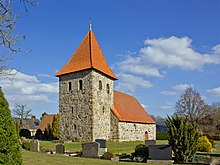
The Protestant chapel is a simple field stone building with a west tower and a recessed round east end. The structure probably dates from the 14th century. There is a round arched portal on the north side of the tower . The simple interior has a wooden beam ceiling.
See also
- List of settlements in the Lüchow-Dannenberg district # Rundlingsdörfer
- List of architectural monuments in Bergen an der Dumme # Nienbergen
Web links
- Photos from Nienbergen on wendland-archiv.de
- The Nienbergen train station
Individual evidence
- ^ Federal Statistical Office (ed.): Historical municipality directory for the Federal Republic of Germany. Name, border and key number changes in municipalities, counties and administrative districts from May 27, 1970 to December 31, 1982 . W. Kohlhammer GmbH, Stuttgart and Mainz 1983, ISBN 3-17-003263-1 , p. 230 .
- ↑ NIENBERGEN Gem. Bergen (stupid), district Lüchow-Dannenberg. Ev. Chapel. In: Georg Dehio : Handbook of German Art Monuments . Bremen Lower Saxony. Deutscher Kunstverlag, Munich / Berlin 1992, ISBN 3-422-03022-0 , p. 981


