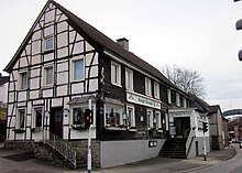
Kidney Court (Rittergut)
The kidney farm was located in the Velbert district of Kidneyhof , which formerly belonged to Westphalia . It was once known as the "Rittergut Nederhofe".
location
Gut Kidneyhof, after which an entire district is named today, was located at the junction of the prehistoric Hilinciweg trade route (mentioned in a document in 875 as the boundary of the Werden Tenth District ) over the Deilbach . The Deilbach is the historical border between Franconia and Saxony , until 1354 between the lordship of Hardenberg and the county of Mark , later between the duchy of Berg and Prussia and to this day between the Rhineland and Westphalia . Since the trade route was of considerable importance, the Isenburg , once the largest hilltop castle in Westphalia, was built on the "Kölner Furt" over the Ruhr . It is likely that the Deilbach crossing was also controlled by a knight's seat. The confluence of the Deilbach, Heiersberger Bach and Felderbach rivers with their wide fertile valleys also appears to be beneficial for the construction of a permanent house. While the streams were used to plant various mills, Kidneyhof has developed into a traffic junction up to the present day. In the "Topographical Chart of the County of Marck from 1777", the kidney courtyard is marked as "an aristocratic estate".
history
Not far from the knight's seat on the Hattingener Homberg was the nobility seat of the von Nederhove family in Kidneyhof (since 1971 district of Langenberg , now Velbert). Until the family died out in the 15th century, the lords of Nederhove were Isenbergisch-Limburg servants. Their residence was on the southwestern foothills of the Isenberg . In 1172 Hellwich v. Nederhove Ministerial of the Church of Cologne . The name Slugh later appears on the Nederhove. In 1360 Gudeke Slugh von Nederhove was enfeoffed by Count Dietrich. Bearers of the same name held the office of judges in Hattingen in the 15th century. In 1757 the merchant Johann Peter Bachmann from Langenberg bought the land that belonged to the estate and built extensive residential and farm buildings on the main road.
Today's building ensemble
Today's country restaurant, on the site of the manor estate acquired by Johann Peter Bachmann in 1757, consists of a two-storey half - timbered building on a rubble stone base. The corner formation was subsequently re-windowed after an entrance pavilion was demolished. The street side (west side) is slated . The outbuilding is made of Ruhr sandstone . At the beginning of the 1980s, after a hall building was demolished, a half-timbered connecting structure was placed between the two main buildings. The end of the ensemble is a courtyard driveway with a long retaining wall and a striking rock formation of an interesting geological outcrop against which the buildings are leaning.
Demolition request and new building proposal
The ensemble of buildings that characterizes the cityscape was not entered in the list of monuments of the city of Velbert. The owner, who ran the building as a country inn for decades, applied for demolition in 2013 . The area should be built with row houses. On the basis of media reports and civic engagement, the Rhineland Regional Council examined the monument value of the building, as well as any archaeological finds in connection with the manor. However, due to the changes that the building had undergone in recent times, the LVR decided not to have the monument registered. However, the owner's proposals for new building were rejected by the city council of Velbert.
Rescue from decay and restoration
The building, which had been vacant since 2014, was then offered by a broker for several years. In 2018 the ensemble of buildings became family property and is being restored as a multi-generation house for residential purposes.
Individual evidence
- ↑ Topographical Map of the County of Marck
- ↑ Paul Freisewinkel: Publications and Writings on Local History, Volume 2, Hattingen 1981 ( Memento of the original from December 15, 2007 in the Internet Archive ) Info: The archive link was inserted automatically and has not yet been checked. Please check the original and archive link according to the instructions and then remove this notice.
- ↑ The inn is to give way to residential buildings
- ↑ The permanent house once stood here
- ↑ The Kidneyhof Inn is supposed to be preserved
- ↑ Lover has taken over the former kidney farm inn
Coordinates: 51 ° 22 ′ 20 ″ N , 7 ° 8 ′ 15.9 ″ E


