
North Head (New Zealand)
|
North Head Māori : Maungauika |
||
|---|---|---|
 North Head with Rangitoto Island and the Hauraki Gulf |
||
| height | 65 m | |
| location | Devonport , Auckland Council , North Island, New Zealand | |
| Coordinates | 36 ° 49 '39 " S , 174 ° 48' 44" E | |
|
||
| Type | Volcanic residue | |
| rock | tuff | |
| Last eruption | 116,000 years ago | |
| Development | old defense system and public reserve | |
 North Head as seen from the south from Tamaki Drive . Mount Victoria can be seen to the west . |
||

North Head , called Maungauika (Mountain of Uika ) in the Māori language , is a leftover core of a former volcano , northeast of downtown Auckland on the North Island of New Zealand. The 65 m high hill also forms the southeastern end of a headland on which the Devonport district ofthe former independent city of North Shore City is located.
geography
North Head , an oval hill 300 to 465 m in diameter, forms the northern corner of the entrance to Waitemata Harbor and is located 4.5 km northeast of central Auckland . While the south side of the derivation faces the harbor entrance, the east side faces the Rangitoto Channel . To the west of North Head is the district of Devonport and to the north extends the headland with the volcanic cone at the end.
geology
The volcano, of which the remains of North Head can still be seen today, must have formed 128,000 to 116,000 years ago and was part of the Auckland Volcanic Field , which includes 53 previously active volcanoes in the Auckland area known today. The sea level was lower at that time than it is now, and yet the places where magma rose to the surface were below the surface of the sea, with tremendous effects when the scorching lava came into contact with water. The North Head was created under these conditions .
history
Māori
The original cinder cone of the volcano was changed initially by the erosion of the sea, later by many generations of people who inhabited the mountain. One of the waka (canoes) in which the Māori came to New Zealand landed nearby , according to the Māori . Some early photographs showed garden terraces created by the Māori on the slopes of the hill. However, no Pā s (fortified villages), as is common on other volcanic cones, appear to have been present on the hill. However, European visitors in the 1850s described a settlement at the foot of the hill with gardens and racks for drying fish.
military
During the European settlement phase of Auckland , the mountain was first used as a pilot station for the harbor pilot of Waitemata Harbor . In 1878 the area was classified as a " public reserve ", with the possibility of using the mountain for defense purposes by the New Zealand Army if necessary . This case occurred as early as 1885 when the conflict between Great Britain and Russia known as The Great Game reached its climax and fortifications were built at various points around Auckland in order to repel possible attackers from the north.
Three gun batteries were erected: the north battery towered over the Rangitoto Channel , the south battery faced inward towards the harbor, and the summit or Cautley battery was on the top of the hill. The first fortifications were built hastily, but later reinforced and expanded with the help of convicts over a period of over 25 years. Up to 40 prisoners lived in a barracks on the summit. They built an extensive system of tunnels, underground storage rooms and various observation posts. The armament comprised 64-pounder Armstrong cannons , which were mounted as so-called Disappearing Guns , searchlights and a remote-detonable minefield across the inner harbor to Bastion Point . None of the weapons were ever used in a conflict. An 18-pounder salute battery from World War I consisting of four cannons was used, among other things, for the salute during the visit of Elizabeth II in 1953.
In the 1930s, part of the fort was modernized. During World War II , it became the administrative center for Auckland's coastal defense. The regimental headquarters building is still preserved. Coastal defense was abandoned in 1950. One of the outdated Disappearing Guns was preserved. It was too difficult for the scrap dealer who bought it to dismantle and transport. After the army withdrew, the area was declared a reservation again, but the New Zealand Navy kept an area around the summit used for training.
use
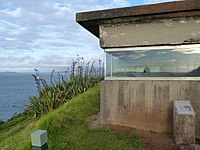
After the Naval School had left the summit area in 1996, the North Head was administered as a reserve by the Department of Conservation . There are hiking trails along the shore and paths to the top with good views of the Rangitoto volcano and Auckland . Most of the tunnels and gun emplacements are open to the public.
In the late 1980s and early 1990s there were reports of strange chemical smells and rumors of hidden caverns under the mountain that went so far that planes would be left in hidden storage rooms. As it was feared that old ammunition might rot in forgotten parts of the fortification, extensive investigations including archival research, geological tests and experimental excavations were carried out, which, however, revealed little new.
tourism
As part of the Hauraki Gulf Maritime Park, the area is known as a public reserve for its views of the harbor and the Hauraki Gulf . From the time it was used for coastal defense, a network of old bunkers and tunnels has been preserved, which have been developed for tourism.
Photo gallery
- North Head and Defense

North Head as viewed from the northwest

The BL 8 inch Mk VII of the southern battery on disappearing carriage

One of the North Head tunnels
Observation post


.JPG)
See also
Web links
- Historic Information - DOC Fact Sheet - North Head Historic Reserve . (PDF 86 kB)Department of Conservation, March 2000,accessed on May 18, 2018.
Individual evidence
- ↑ a b c d e f History of the reserve . Department of Conservation , archived from the original on September 30, 2007 ; accessed on May 18, 2018 (English, original website no longer available).
- ↑ a b Topo250 maps . Land Information New Zealand , accessed May 18, 2018 .
- ↑ Coordinates and longitudes were determined using Goggle Earth Pro Version 7.3.1.4507 on May 18, 2018
- ↑ Javier Agustín-Flores, Károly Németh, Shane J. Cronin, Jan M. Lindsay, Gábor Kereszturi : Construction of the North Head ( Maungauika ) tuff cone: a product of Surtseyan volcanism, rare in the Auckland Volcanic Field, New Zealand . In: Bulletin of Volcanology . Volume 77, Article-ID 11 , February 2015, p. 17 , doi : 10.1007 / s00445-014-0892-9 , bibcode : 2015BVol ... 77 ... 11A (English).
- ↑ a b Information from various memorial plaques of the DOC on North Head
- ^ Wally Ruffell : Disappearing Guns . Royal New Zealand Artillery Association , March 2001, archived from the original on November 28, 2010 ; accessed on May 18, 2018 (English, original website no longer available).