Oberdielbach
|
Oberdielbach
Community Waldbrunn
|
|
|---|---|
| Coordinates: 49 ° 26 ′ 55 ″ N , 9 ° 3 ′ 17 ″ E | |
| Height : | 480 m |
| Area : | 7.3 km² |
| Residents : | 1103 (December 31, 2015) |
| Population density : | 151 inhabitants / km² |
| Incorporation : | 1st January 1973 |
| Postal code : | 69429 |
| Area code : | 06274 |
|
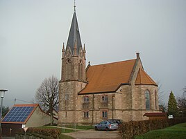
Church in Oberdielbach
|
|
Oberdielbach is a part of the community Waldbrunn in the Neckar-Odenwald district in Baden-Württemberg .
Geographical location
Oberdielbach is located in the southeastern part of the Odenwald in its red sandstone area on the Winter Hauch , an elongated plateau that culminates 2.6 km further north-northwest in the highest mountain in the Odenwald, the Katzenbuckel ( 626.8 m ). The location follows the upper reaches of the Holderbach for around one and a half kilometers of valley length to the southwest to the city limits of Eberbach , beyond which the development continues in the hamlet of Unterdielbach , a district of the neighboring city and its core area. The Holderbach flows towards the Itter at the level of the Eberbach city center . In the north of the field markings is the Meisental settlement and in the south the hamlet of Oberdielbach-Post . The main part of the forest area adjoins southwest of the hamlet and extends to the heights above the right bank of the Neckar near the Zwingenberg Castle . The district covers 730 hectares, of which 297 hectares are forested.
Strümpfelbrunn , the main town in the Waldbrunn community, is located around two and a half kilometers northeast of the center of Oberdielbach. In the north the holiday village Waldbrunn and immediately behind it the district Waldkatzenbach and in the southeast the district Schollbrunn .
history
The existence of Dylbach can be traced back to 1360 when the Lords of Zwingenberg were founded . In 1746 the place came with the entire rule of Zwingenberg to the Electoral Palatinate. The Protestant church was built in 1902/1903.
The name Oberdielbach came up in the 16th century to distinguish it from the hamlet of Unterdielbach, which was built adjacent to the Eberbach area .
On January 1, 1973, Oberdielbach and four other communities formed the new community of Waldbrunn.
traffic
The state road L 524 leads from Eberbach to Mudau over the Winter Hauch and thus through Oberdielbach . In the center of the village, the L 634 branches off to the south in the direction of Schollbrunn and Neckargerach .
Individual evidence
- ^ Federal Statistical Office (ed.): Historical municipality directory for the Federal Republic of Germany. Name, border and key number changes in municipalities, counties and administrative districts from May 27, 1970 to December 31, 1982 . W. Kohlhammer, Stuttgart / Mainz 1983, ISBN 3-17-003263-1 , p. 478 .
Web links
- Oberdielbach on the website of the community of Waldbrunn , accessed on December 7, 2018
- LEO-BW, discover regional studies online Oberdielbach

