Upper paper mill (Wiesentheid)
|
Upper paper mill
Wiesentheid market
Coordinates: 49 ° 47 ′ 35 " N , 10 ° 18 ′ 45" E
|
|
|---|---|
| Height : | 225 m |
| Postal code : | 97353 |
| Area code : | 09325 |
|
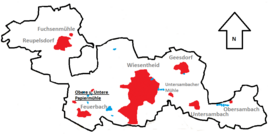
Location of the upper paper mill (bold) in the Wiesentheider municipality
|
|
The Upper paper mill is a remote area in the district of Wiesent Heider hamlet Feuerbach in the Lower Franconian district of Kitzingen . The lower paper mill also exists near Feuerbach .
Geographical location
The Obere Papiermühle is located in the northwest of the Wiesentheider municipality on the Castellbach tributary Sambach. To the north, the municipality of Prichsenstadt begins with the district of Laub . Wiesentheid is to the east and the district of Rüdenhausen begins in the southeast . Feuerbach is to the south. To the west begins the area of Kleinlangheim with the districts Atzhausen and Pfundmühle at some distance .
history
The Obere Papiermühle is the younger of the two former paper mills around Feuerbach. A Thuringian papermaker brought the craft to the village in 1713 . After the already existing Heinrichsmühle had been converted into a paper mill, a competing company arose in 1773 with the Oberen Papiermühle am Sambach. It was headed by Wilhelm Eberhard and fell victim to industrialization in 1862 .
literature
- Alexander Graf zu Castell: Feuerbach . In: Jesko Graf zu Dohna (ed.): Kulturpfad. In the footsteps of the Counts of Castell . Münsterschwarzach 2004. pp. 86–87.
- Karl Treutwein : From Abtswind to Zeilitzheim. History, sights, traditions . Volkach 4 1987.

