Obersambach
|
Obersambach
Wiesentheid market
Coordinates: 49 ° 47 ′ 16 ″ N , 10 ° 24 ′ 11 ″ E
|
|
|---|---|
| Height : | 315 m |
| Residents : | 2 (1987) |
| Postal code : | 97353 |
| Area code : | 09383 |
|
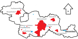
Location of Obersambach (bold) in the Wiesentheider municipality
|
|
Oberambach is a remote area in the district of Wiesent Heider hamlet Under Ambach in the Lower Franconian district of Kitzingen .
Geographical location
Obersambach is on the edge of a forest clearing in the extreme southeast of the Wiesentheider municipality. The area of the city of Prichsenstadt begins to the north , the district of Rüdern is closest to Obersambach. At some distance the district merges into that of the Geiselwinder district of Gräfenneuses . To the south is the district of Abtswind , the Steigerwaldberg Friedrichsberg with the hamlet of the same name rises only a few meters away. To the west is Untersambach. The Sambach flows to the south and feeds a number of ponds there. The Hertrichshausen desert is localized in the literature in the settlement triangle Wiesentheid, Obersambach and Gräfenneuses. The settlement was probably abandoned in the 14th century.
The closest larger towns are Gerolzhofen , which is about 13 kilometers away, and Kitzingen , which is about 18 kilometers away.
history
Obersambach was first mentioned in 1356 when Johannes Zöllner zu Rimbach received a fief for three and a half Huben in the village. The village of Obersambach reappeared in the springs in 1413. A few years later, in 1457, some owners of four Huben are named. The brothers Götz and Hans von Wipfeld were mentioned as fiefs of the Counts of Castell .
On March 14, 1466, more people turned up who were wealthy in the village: Some goods belonging to the Lords of Seinsheim / Schwarzenberg were sold to the Ilmbach Charterhouse . At that time the village was called "Obersampach". In 1498 there was a dispute between the communities of Abtswind and Obersambach. Both villages claimed ownership of the Kemrode forest . At that time the village was one of the larger hamlets in the Steigerwald foreland.
During the German Peasant War in 1525 "the whole village was burned away" and from then on lay desolate. In 1588, Hans Fuchs von Dornheim zu Wiesentheid sold some field estates in the Obersambach district to the monastery in nearby Ilmbach . A year later, Fuchs von Dornheim built a barn in Obersambach. Otherwise there was no house in the district. In 1690 the corridor became part of Abtswind . Today Obersambach consists of a single Aussiedlerhof from 1816.
Say
The old size
Several legends arose in the population about the past of the Obersambacher Hof. The Obersambach people are said to have sold their community forest for a very low price during a famine . Then began the decline of the flourishing village. There is also a legend that the settlement was only destroyed in the Thirty Years War . In addition, Untersambach is said to have been a branch of the church in Obersambach. Obersambach was therefore more important than Untersambach.
The gold mine
In the Obersambacher Wald there was once a ditch that ran full of water when it rained. When it was dry, it kept smoking from the ditch. The legend speaks of a ghost from Gräfenneuses who is said to have been banished there. It is said to be a deceased farmer from Gräfenneuses who was put in a bottle by a chimney sweep . When the Schlotfeger the bottle showed the daughters of farmers, was one in swoon while the other was happy about the whereabouts of her father.
The bells of the Obersambach church are said to have been buried in the gold mine. The population had probably tried to hide the valuables from the church from the approaching farmers. After the village went under, there was no one left who could reveal the hiding place. On Holy Night , at the time of Mette , some people heard the bells of Obersambach in the forest. There is also the legend that money is hidden.
literature
- Johann Ludwig Klarmann, Karl Spiegel: Legends and sketches from the Steigerwald. Reprint of the 1912 edition . Neustadt an der Aisch 1982.
- Roderich Machann: Desolations in the Steigerwald (= Mainfränkische Studien Vol. 5). Diss . Wuerzburg 1972.
- Erwin Riedenauer: Desolation between the Main and Steigerwald . In the yearbook for Franconian regional research, vol. 47 , Würzburg 1987
- Peter Rückert: Land expansion and desertification of the high and late Middle Ages in the Franconian Gäuland. Diss . Wuerzburg 1990.
Web links
Individual evidence
- ↑ Machann, Roderich: deserted villages in the Steigerwald . P. 52.
- ^ Rückert, Peter: Land expansion and desertification in the high and late Middle Ages . P. 233.
- ↑ Digital collections: Erwin Riedenauer: Wüstungen between Main and Steigerwald . In: Yearbook for Franconian State Research. Vol. 47 . Page 16 , accessed October 23, 2016
- ↑ Klarmann, Johann Ludwig (among others): Legends and sketches from the Steigerwald . P. 181.

