Ilmbach
|
Ilmbach
City of Prichsenstadt
Coordinates: 49 ° 48 ′ 15 ″ N , 10 ° 24 ′ 33 ″ E
|
|
|---|---|
| Height : | 325 m |
| Residents : | 6 (1987) |
| Postal code : | 97357 |
| Area code : | 09383 |
|
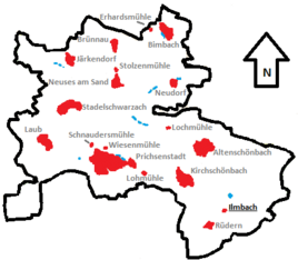
Location of Ilmbach (bold) in the Prichsenstadt municipality
|
|
|
The Schönborn hunting lodge in Ilmbach / Steigerwald
|
|
Ilmbach is a hamlet in the district of Prichsenstadt hamlet church Schönenbach in the Lower Franconian district of Kitzingen . It is located on a hill 325 meters above sea level in the Steigerwald . For the census on May 25, 1987, six residents were found in two residential buildings.
Geographical location
Ilmbach is located in the far east of the Prichsenstadt municipality. To the north begins the district of Altenschönbach , which is also a Prichsenstadt district. Some distance to the east is the Geiselwind area , the Ebersbrunn district is closest to Ilmbach. To the south lies Obersambach in the Wiesentheider area. The west is taken by Geesdorf , also part of Wiesentheid. Kirchschönbach rises to the northwest .
history
Old maps (from 1853) show the Ilmbacher mill (on the Saugraben) a good 200 meters north of Ilmbach. However, nothing can be seen here on current satellite images. The Fallmeister homestead , 250 meters further north-northwest, is already in the neighboring district of Kirchschönbach ( Fallmeister = skinner ). It is no longer referred to by name on current maps as a separate individual settlement.
As early as 1281 the villages "Rudern and Ilmech" were named together in a document. In 1454 Magdalena von Vestenberg and her husband, Ritter Balthasar von Berg, founded the Ilmbach Monastery , a Carthusian monastery in Ilmbach .
It was destroyed in the Peasants' War in 1525 , but not finally dissolved until 1803. The monastery buildings are said to have been demolished by 1867.
The Count von Schönborn bought the village of Ilmbach and the neighboring Rüdern, and in 1800 the villages were dissolved. In 1870, the formally still existing municipality of Rüdern with the districts of Rüdern and Ilmbach was incorporated into the neighboring municipality of Kirchschönbach , which in 1972 was incorporated into Prichsenstadt as part of the regional reform in Bavaria (along with nine other municipalities). Rüdern still exists as one of the eleven districts of Prichsenstadt, the extent of which corresponds to the former municipalities.
Attractions
The wasteland belonging to Prichsenstadt became known for its particularly attractive location and for the hunting lodge that was built in the 19th century and is owned by the Schönborn counts of Wiesentheid .
The Rüdern wildlife park , also owned by the count, is located in the immediate vicinity of Ilmbach and is a popular excursion destination and local recreation area.
literature
- Johann Ludwig Klarmann, Karl Spiegel: Legends and sketches from the Steigerwald. Reprint of the 1912 edition . Neustadt an der Aisch 1982.
- Roderich Machann: Desolations in the Steigerwald (= Mainfränkische Studien Vol. 5). Diss . Wuerzburg 1972.
- Karl Treutwein : From Abtswind to Zeilitzheim. History, sights, traditions . Volkach 1987.
Web links
Individual evidence
- ↑ a b Bavarian State Office for Statistics and Data Processing (Ed.): Official local directory for Bavaria, territorial status: May 25, 1987 . Issue 450 of the articles on Bavaria's statistics. Munich November 1991, DNB 94240937X , p. 365 ( digitized version ).
- ↑ Original position sheets Bavaria, sheet 175 Prichsenstadt
- ↑ Machann, Roderich: deserted villages in the Steigerwald . P. 125.
- ^ Official Journal Prichsenstadt from May 29, 2010
- ^ Wilhelm Volkert, Richard Bauer: Handbook of the Bavarian offices, communities and courts 1799–1980 , page 472
- ↑ Bavarian State Office for Statistics and Data Processing (Hrsg.): The municipalities of Bavaria according to the territorial status May 25, 1987. The population of the municipalities of Bavaria and the changes in the acquisitions and territory from 1840 to 1987 (= contributions to Statistics Bavaria . Issue 451). Munich 1991, p. 113 , urn : nbn: de: bvb: 12-bsb00070717-7 ( digitized version ).
- ↑ Link “Register of districts and municipalities”: Bavarian Register of Landmarks ( Memento of the original from December 17, 2015 in the Internet Archive ) Info: The archive link was inserted automatically and has not yet been checked. Please check the original and archive link according to the instructions and then remove this notice.
- ↑ Bavarian Surveying Administration: BayernViewer-plus: Maps: Administrative boundaries: District


