Erhardsmühle (Prichsenstadt)
|
Erhardsmühle
City of Prichsenstadt
Coordinates: 49 ° 51 ′ 42 " N , 10 ° 22 ′ 3" E
|
|
|---|---|
| Height : | 252 m |
| Residents : | 5 (1987) |
| Postal code : | 97357 |
| Area code : | 09382 |
|
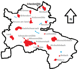
Location of the Erhardsmühle (bold) in the Prichsenstadt municipality
|
|
The Erhardsmühle (formerly also Erichsdorf , Eherichsdorf , Erichesdorf , Erisdorf ) is a wasteland on the boundary of the Prichsenstadt district of Bimbach in the Lower Franconian district of Kitzingen .
Geographical location
The Erhardsmühle is located in the far north of the Prichsenstadt municipality. The district of Schweinfurt begins to the north , the municipality of Lülsfeld with the district of Schallfeld is closest to it. To the east is the village of Bimbach, where the mill is located, to the southeast is Neudorf and to the west is Brünnau , both of which, like the mill, are part of the town of Prichsenstadt.
Closest towns are Gerolzhofen , which is about five kilometers away, and Volkach , which is about ten kilometers away.
history
Around the year 1230 a village appeared for the first time on the site of today's mill in the springs. At that time, a Hermann von Morstein sold parts of his property to Hartlieb von Stolberg. This now owned "all houses in Erichesdorf" ( Latin totam villam in Erichesdorf ). A decade later, in 1331, the Stolzenberg fief came to Sifrid Gruzzer. The village had previously been in the hands of Hermann Lamperti for a short time.
In 1346 Sifrid Gruzzer received a fief in the village. In 1395 the "Eherstorff" estate was in the hands of Hans Arnold von Brünnau, who also cultivated the fields. At the end of the 14th century the village was largely desolate, only the mill remained. Hans von Lauffenholz awarded the village as an after fief in 1456 . At that time the settlement was called "zu der Ehersmühle".
In the years 1574 and 1589, the village was only referred to as a desert , so it can be assumed that the population had left the village in the 16th century. In 1574, for example, people spoke of the "village of Ersdorff". Only the mill on the Schwarzachbach remained settled over the centuries and was later incorporated into the nearby village of Bimbach, which today belongs to the Prichsenstadt community .
An inscription that mentions the miller "Georgius Palteser Holtzwart" in 1569 was placed on a stone tablet on the current buildings of the mill . In 1731 Johann Michael Glückert owned the Erhardsmühle. In 1889 Wilhelm Grimmer and his wife Barbara, née Gräbner, sold the system to Johann Jobst May from Sterchenheim . At that time there was both a grinding and a sawmill on the site.
At the end of the 19th century, the mill passed to the Kirchberger family. Johann Georg Leonhard Kirchberger was born in the Nonnenmühle near Uehlfeld and later came to Bimbach. Here he married the Erhard miller Frieda May in 1927. Most recently, Karl Johannes Kirchberger sat with his wife Anna Marie Linz from Prichsenstadt on the mill. Today the existing buildings have been converted into modern residential buildings.
Attractions
The Erhardsmühle is registered as an architectural monument by the Bavarian State Office for the Preservation of Monuments . It is a two-storey hipped roof building with a drilled door frame. The core of the property was built in 1569, and the mill was renewed in 1731, as evidenced by the year above the door. The former sawmill next to the main building dates from the 19th century and is also listed as a monument.
literature
- Volker Bolesta, Karl-Heinz Leibl: Mills in the large community of Prichsenstadt (= Prichsenstädter Eulenspiegel 10) . Prichsenstadt 2015.
- Roderich Machann: Desolations in the Steigerwald (= Mainfränkische Studien Vol. 5). Diss . Wuerzburg 1972.
- Erwin Riedenauer: Desolation between the Main and Steigerwald . In: Yearbook for Franconian State Research. Vol. 47 . Wuerzburg 1987.
- Peter Rückert: Land expansion and desertification of the high and late Middle Ages in the Franconian Gäuland. Diss . Wuerzburg 1990.
Web links
Individual evidence
- ^ Bavarian State Office for Statistics and Data Processing (Ed.): Official local directory for Bavaria, territorial status: May 25, 1987. Issue 450 of the articles on Statistics Bavaria. Munich November 1991, p. 365 ( digitized version ).
- ↑ a b Digital Collections: Erwin Riedenauer: Wüstungen between Main and Steigerwald . In: Yearbook for Franconian State Research. Vol. 47 . Page 42 , accessed October 28, 2016.
- ^ Rückert, Peter: Land expansion and desertification of the high and late Middle Ages . P. 172.
- ↑ Machann, Roderich: deserted villages in the Steigerwald . P. 107.
- ↑ Bolesta, Volker (among others): mills in the large village Prichsenstadt . P. 27.
- ↑ Bolesta, Volker (among others): mills in the large village Prichsenstadt . P. 26.

