
Upper Palatinate Lake District

The Upper Palatinate Lake District is a lake landscape predominantly in the southern part of the Schwandorf district , between Schwandorf and Wackersdorf . After the end of open-cast mining in the Upper Palatinate lignite district in 1982, the former open- cast mines were filled with water as part of a concept for redesigning the areas. The total water area is over 800 hectares.
Lakes
Some of the lakes have been developed for bathing and water sports. The largest lake is the Steinberger See with an area of 1.86 km² and a maximum depth of 50 meters. Other lakes developed for leisure activities are Murner See (0.9 km²), Brückelsee (1.5 km²), Eixendorfer Stausee (1.10 km²), Ausee, Klausensee near Schwandorf, Hammersee (0.64 km²) in Bodenwöhr , Green Lake near Schwarzenfeld , Mühlweiher near Thanstein . There are also a large number of ponds that are not open to tourists.
The Karpfenland middle Upper Palatinate includes 2,408 ponds (6.69 km²) and 307 lakes (10 km²) in the Schwandorf district. The nature reserve Charlottenhofer Weihergebiet is the "heart" of the Karpfenland.
Emergence
Almost all of the lakes were created artificially through lignite mining or gravel mining. The water of the brown coal lakes is acidic due to the leaching of the former spoil on the bottom, the fish population is limited or not available, but is developing. The vegetation along the banks ( reeds ) or in the water ( algae ) also develops very slowly or not at all. The former gravel pits are mostly used by fishing clubs, among others.
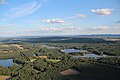
Picture gallery

Schwandorf Airfield in the Lakeland

Steinberger See

Upper Palatinate Lake District

Upper Palatinate Lake District
Upper Palatinate Lake District

Ausee in the Upper Palatinate Lake District (2013)

Murner See (2014)

Murner See (2014)


See also
Individual evidence
- ↑ Local development strategy Karpfenland Middle Upper Palatinate (pdf)
- ↑ Karpfenland Middle Upper Palatinate
Web links
- Oberpfälzer Seenland - (Zweckverband)
- Oberpfälzer Seenland - (Upper Palatinate aerial view)
- Oberpfälzer Seenland - (image film on YouTube, approx. 4 min.)
Coordinates: 49 ° 16 ′ 44.4 " N , 12 ° 9 ′ 46.8" E