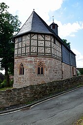
Oberrosphe
|
Oberrosphe
City of Wetter (Hessen)
|
|
|---|---|
| Coordinates: 50 ° 54 ′ 41 ″ N , 8 ° 46 ′ 31 ″ E | |
| Height : | 237 m above sea level NHN |
| Area : | 21.66 km² |
| Residents : | 752 (Jun 30, 2017) |
| Population density : | 35 inhabitants / km² |
| Incorporation : | December 31, 1971 |
| Postal code : | 35083 |
| Area code : | 06423 |
Oberrosphe is a district of Wetter (Hessen) in the district of Marburg-Biedenkopf in Central Hesse .
geography
The place is northeast of Wetter am Burgwald . District road 2 runs through the village .
history
Oberrosphe is a Celtic foundation. They called the village roos-affa , which means “swampy, putrid water”. The place was first mentioned in writing in a document around 800. The first church (today Protestant) was built around 1000. In 1535, Landgrave Philip I had an official seat built in the village for the "riding forester and chief forester in the castle forest".
On December 31, 1971, Oberrosphe was incorporated into the city of Wetter (Hessen-Nassau) (the city's name at the time) .
Culture and sights
- There is a local museum in the old forest farm . The preserved residential building was erected in 1750 and replaced the previous building from 1535.
- In 1983, in the competition “Our village should become more beautiful” , the town won a gold medal at the federal level.
- Oberrosphe belongs to a Protestant parish with Unterrosphe and Göttingen .
Infrastructure
- In 2007 Oberrosphe citizens to joined in cooperative together to district heating from bioenergy to generate. For this purpose, a pipe network was laid and a thermal power station was built.
Web links
- Oberrosphe district on the website of the city of Wetter.
- Oberrosphe. Local history, information. In: www.oberrosphe.de. Private website
- Oberrosphe, Marburg-Biedenkopf district. Historical local dictionary for Hessen. In: Landesgeschichtliches Informationssystem Hessen (LAGIS).
- Literature on Oberrosphe in the Hessian Bibliography
Individual evidence
- ↑ a b Budget 2016 (statistical information) of the city of Wetter (PDF 5.4 MB)
- ^ Federal Statistical Office (ed.): Historical municipality directory for the Federal Republic of Germany. Name, border and key number changes in municipalities, counties and administrative districts from May 27, 1970 to December 31, 1982 . W. Kohlhammer GmbH, Stuttgart / Mainz 1983, ISBN 3-17-003263-1 , p. 402 .
- ↑ The bioenergy village


