Oberst-Klinke-Hut
| Oberst-Klinke-Hütte ÖAV-Hütte Category II |
||
|---|---|---|
|
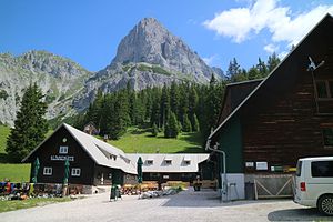
Klinkehütte in front of the Admonter Kalbling |
||
| location | at the foot of the Reichenstein group ; Styria , Austria ; Valley location: Admont | |
| Mountain range | Gesäuse Mountains , Ennstal Alps | |
| Geographical location: | 47 ° 32 '22.2 " N , 14 ° 30' 50.1" E | |
| Altitude | 1486 m above sea level A. | |
|
|
||
| owner | PES section Admont-Gesäuse | |
| Built | 1941 | |
| Construction type | hut | |
| Development | toll road | |
| Usual opening times | all year round, closed on Mondays | |
| accommodation | 15 beds, 110 camps | |
| Winter room | 1 warehouse | |
| Hut directory | ÖAV DAV | |
The colonel jack lodge (short jack hut ) is a refuge of the PES in the Gesäuse mountains in Styria . The U-shaped building was built in the Second World War as a training base for mountain hunters .
Location and surroundings
The Klinkehütte is located at 1486 m above sea level. A. (according to ÖAV 1504 m above sea level ) at the southern foot of the Reichenstein range, southeast of Admont . Above the hut, the striking Admonter Kalbling towers up with its south and west walls, a popular hiking and climbing destination. South of the hut is the Lahngangkogel ( 1778 m ) with the Wagenbänkalm. The Kalblinggatterl is located 200 meters east of the building , a 1542 m high transition to the Flitzengraben with the dilapidated alpine pastures of the same name, which borders the Reichenstein group to the south. From the west of the Kaiserau (ski area) a toll gravel road leads to the hut, in the east a toll road from Gaishorn to the rear Flitzengraben, from where the Klinkehütte and Mödlinger Hütte can be reached.
history
The hut was built from 1938 under the colonel of the German armed forces Rudolf Klinke. Formally, however, the “Bergsportverein Gesäuse” founded by Klinke was the client. After Klinke's death in 1939, the building was completed in 1941 under Major Alexander Götz. During the war , the Oberst-Klinke-Hütte served the Wehrmacht as an alpine training base. After the end of the war, the U-shaped building was initially classified as German property by the occupying powers , but could be regained by the local builder, the mountain sports club.
After that, the hut was run by Naturefriends for 13 years before it was acquired by the Admont section of the Austrian Alpine Club in 1959 . In 1967 the landowner, the Admont Benedictine Abbey , had a toll road built to the hut, which became a destination for motorists and lost its original hut character. In the same year a ski lift was built, the operation of which was maintained for three decades. In 1969 the neighboring Kanduth-Mühlanger-Hütte was built, which has since served as a base for the Gesäuse Alpine Rescue Service . The increasing number of visitors led to the expansion of the Klinkehütte in 1970. Since the first post-war years, the house has been a heavily frequented base for climbing routes on Kalbling and Sparafeld .
In 2015, both the Klinkehütte and the mountain rescue hut underwent a six-week general renovation. Volunteers worked around 3500 hours, with local businesses supporting the project with material donations. In the future, the Alpine Club wants to dedicate the hut, which has a climbing wall for practice and a separate seminar room, to its original function as an Alpine training facility. Organizations such as mountain rescue and alpine police should be addressed in particular .
tourism
Since the ski lifts closed, the road to the hut is no longer passable in winter and has been converted into a natural toboggan run . The hut also serves as a popular base for ski tourers in winter . In summer, the road is often used by mountain bikers . The hut is located on the long-distance hiking trails Nordalpenweg 01 and Eisenwurzenweg 08 as well as on the European long-distance hiking trail E4 .
Access to the hut
- from the west from Kaiserau : 1½ hours
- from the Mödlinger Hütte via the Kalblinggatterl: 2 hours
- from Bärndorf : 2¾ hours
- from Admont via Kaiserau: 3 hours
- from Gaishorn (toll road) through the Flitzengraben: 3½ hours
- of shoots : 3½ hours
Tour destinations
- Lahngangkogel ( 1778 m ): 1 hour
- Riffel ( 2106 m ): 1¾ hours
- Admonter Kalbling ( 2196 m ): 2 hours
- Sparafeld ( 2247 m ): 2 hours
- Hahnstein ( 1697 m ): 2 hours
- Kreuzkogel ( 2011 m ): 2½ hours
Neighboring huts
- Mödlinger Hut (1,523 m), 2 hours
cards
- Alpine club map sheet No. 16, Ennstal Alps - Gesäuse (1: 25,000)
Web links
Individual evidence
- ^ BEV, Federal Office for Metrology and Surveying, ÖK 50 (Austria map 1: 50,000), also available online [1] .
- ↑ a b Klinkehütte. PES , accessed on July 3, 2016 .
- ↑ Repositioning of the Klinkehütte. Der Ennstaler, November 5, 2015, accessed on July 3, 2016 .
- ↑ © Österreichischer Alpenverein, Klinkehütte: Klinkehütte, Ennstaler Alpen Klinkehütte key data / home page. Retrieved September 27, 2019 .
- ↑ Alpine Club Maps of the Eastern Alps. Retrieved September 27, 2019 .


