Oblík (Central Bohemian Mountains)
| Oblík | ||
|---|---|---|
|
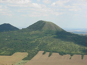
View from Raná to Oblík |
||
| height | 509.2 m nm | |
| location | Czech Republic | |
| Mountains | Central Bohemian Uplands | |
| Coordinates | 50 ° 24 ′ 41 ″ N , 13 ° 48 ′ 31 ″ E | |
|
|
||
| Type | Kegelberg | |
| rock | basalt | |
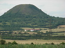
The Oblík (German Hoblik , 509 m) is a prominent mountain in the so-called Launer part of the Bohemian Central Mountains ( České středohoří ) in the Czech Republic . The Oblík National Nature Reserve has existed since 1967 .
Location and surroundings
The Oblík is located about six kilometers north of Louny ( Laun ) and 12 kilometers southeast of Most ( Brüx ) in the Bohemian Central Uplands on the left Elbe. Immediately at the foot of the mountain is the municipality of Raná ( Rannay ) and the small towns of Mnichov ( Minichhof ) and Chraberce . Neighboring mountains are the Raná ( Rannayer ) Srdov ( Long Mountain ), Brník ( Buschberg ) and decimated by a quarry Týnecký Chlum .
Until 1945/46, the language border between German and Czech populated areas ran on the Oblík. After the Sudetenland was annexed to Germany in autumn 1938, the Oblík was entirely on German territory ; the new state border was established immediately south of the Oblík.
natural reserve
Since 1967 the mountain has been under state protection as a national nature reserve on 20.5 hectares . Both the dry grassland on the south side with its warmth- loving steppe vegetation and the north side, which is covered with a sparse deciduous forest, are protected . Characteristic for the reserve are also the extensive stocks of dog rose and blackthorn , which provide a home for many endangered bird species.
The Oblík is famous above all for its rich population of the spring Adonis beauty ( Adonis vernalis ) at the foot of the south and east side as well as on the summit, which occurs here on the north-western limit of its range. Other typical plants of the dry grasslands are the endemic Bohemian meadow anemone ( Pulsatilla pratensis bohemica ), the Purple Mullein ( Verbascum phoeniceum ) the real feather grass ( Stipa pennata ) and the steppe Wild Oats ( Avenastrum desertorum ). Today's picture represents the result of former management u. a. as pastureland. Grazing has contributed to the preservation of the flora since 1977. a. promotes the spread of the spring Adonis. The silvery billowing feather grasses from late May to mid-June are impressive.
The deciduous forest on the north side is mainly dominated by sessile oak , sycamore maple and ash . Noteworthy is the occurrence of some rare spring bloomers in the undergrowth, such as yellow anemone ( Anemone ranunculoides ), cowslip ( Primula elatior ) and various types of violets .
Paths to the summit
The Oblík has only been the destination of marked hiking trails for a few years. Since then, a green marked hiking route from Louny and continuing to Mnichov has led to Oblík. Drivers start best in Mnichov (parking facilities). The old, serpentine path on the steep southern flank is remarkable.
The ascent on the west side along an unmarked, extremely steep path should not be attempted for nature conservation reasons.
literature
- Peter Rölke (Ed.): Hiking and nature guide Bohemian Central Mountains. Berg- und Naturverlag Rölke, Dresden 2008


