Ojuelos de Jalisco
| Ojuelos de Jalisco | ||
|---|---|---|
|
Coordinates: 21 ° 52 ′ N , 101 ° 36 ′ W Ojuelos de Jalisco on the map of Jalisco
|
||
| Basic data | ||
| Country | Mexico | |
| State | Jalisco | |
| Municipio | Ojuelos de Jalisco | |
| City foundation | 1569 | |
| Residents | 11,881 (2010) | |
| City insignia | ||
| Detailed data | ||
| surface | 4.39 km 2 | |
| Population density | 2,706 inhabitants / km 2 | |
| height | 2220 m | |
| Website | ||
| Ojuelos - caravan yard (fuerte) | ||
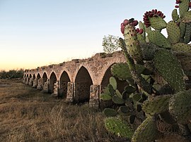
| Ojuelos Bridge (puente) | ||
| Place El Parian | ||
Ojuelos de Jalisco is a small town with about 12,000 and the capital of a municipality ( municipio ) of about 32,000 inhabitants in the Mexican state of Jalisco . The historic center of the city belongs since 2010 to UNESCO - World Heritage Sites of Camino Real de Tierra Adentro .
Location and climate
Ojuelos de Jalisco is about 450 km (driving distance) northwest of Mexico City at an altitude of about 2220 m ; the “silver cities” San Luis Potosí (approx. 85 km to the northeast), Guanajuato (approx. 170 km southeast) and Zacatecas (approx. 200 km northwest) are in the wider area. The climate is warm; Rain (approx. 525 mm / year) falls mainly in the summer half-year.
Population development
| year | 2000 | 2005 | 2010 |
| Residents | 9,338 | 10,698 | 11,881 |
The slight but steady increase in population is mainly due to the ongoing immigration of families from the surrounding villages.
economy
Livestock raising (cattle, sheep, goats, pigs) plays the most important role in the life of the community; In addition, the cultivation of grain (maize, wheat, barley) and the cultivation of fruits and vegetables (beans, chillies, tomatoes, prickly pears, peaches, pears, figs, walnuts) are important. Small traders, craftsmen and service providers of all kinds have settled in the city itself.
history
Before the arrival of the Spaniards, the area belonged to the Chichimec settlement area . The city, founded in 1569 on the orders of the then Viceroy Martín Enríquez de Almansa to protect the "Silver Road" (Camino Real de Tierra Adentro) from Mexico City via Guanajuato to Zacatecas, got its name from the numerous sources (ojos de agua) in it Surroundings.
Attractions
- The huge walled courtyard (fuerte) with only one entrance and a fountain probably formed the origin of the city; it is the only one of the former 7 of its kind and served as a protected resting place for the silver caravans passing through. Its arcades were used as sleeping places for people and animals; there is still a kind of guard and battlements above.
- The local parish church (Templo Parroquial de San José) was built in the 18th century. While the facade and the bell tower with its mounted lantern were built from reddish stone, the rest of the church is plastered. The yoke in front of the apse is domed , as is customary in baroque churches in Mexico.
- The Templo de la Virgen del Refugio or just Templo del Santuario is a stone-faced church in the neoclassical style.
- The Plaza Hidalgo (also called El Parían ) was built in the 1880s; it is lined with 108 arcades with shops, offices, etc. It also serves as a central event space.
- The former town hall (today Casa de Cultura ) was built in 1901. One wall of the arcaded courtyard is decorated with frescoes in the style of Diego Rivera .
- Surroundings
- Approx. 3 km northeast of the city, a multi-arch bridge (Puente de la Plata) built in the 17th century crosses a swampy river that keeps falling dry.
- The town of Matancillas is also worth seeing .


