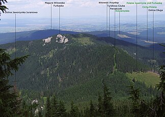
Arwa Witów Summit
| Pogórze Gubałowskie | ||
|---|---|---|
|
View from the Western Tatras |
||
| Highest peak | Magura Witowska ( 1232 m npm ) | |
| location | Poland , Slovakia | |
| part of | Western Carpathians | |
|
|
||
| Coordinates | 49 ° 18 ′ N , 19 ° 47 ′ E | |
The Arwa-Witów Summit (Polish Orawicko-Witowskie Wierchy ) is a mountain range in eastern Slovakia and the Polish Lesser Poland Voivodeship in the Powiat Tatrzański district and the municipalities of Zakopane , Kościelisko and Czarny Dunajec . It is on the border between the historical regions of Orava and Podhale . The main ridge forms the border between the two regions and states.
location
The mountain is located north of West Tatras (limit is the trench Rów Podtatrzański ), south of the boiler Kotlina Nowotarska , west of the Foothills Gubałowskie (limit is the mountain river Czarny Dunajec ) and east of Skoruszyńskie Wierchy (limit is the mountain river Orawica ), the hills of Pogórze Spisko-Gubałowskie . It has the character of a low mountain range . The highest point is at 1232 m. above sea level is the Magura Witowska .
tourism
The Pogórze Gubałowskie is relatively sparsely populated. The Polish part of the mountain range is more densely populated than the Slovak part. The Witów-Ski ski area is located on the Polish side . The Termy Chochołowskie thermal baths are located on the Dunajec mountain river in Chochołów .
panorama
Web links
proof
- Witold Henryk Paryski, Zofia Radwańska-Paryska, Wielka encyklopedia tatrzańska, 2004, Wydawnictwo Górskie, Poronin, isbn = 83-7104-009-1


