
Oselstrasse
| Oselstrasse | |
|---|---|
|
|
|
 |
|
| Road sign | |
| Basic data | |
| State capital | Munich |
| Borough | Pasing-Obermenzing |
| Created | from 1892 |
| Hist. Names | Richard-Wagner-Strasse |
| Name received | 1947 |
| Connecting roads | Marsopstrasse |
| Cross streets | Theodor-Strom-Strasse, Ludwig-Thoma-Strasse, Orthstrasse |
| Places | Wensauerplatz |
| Numbering system | Orientation numbering |
| use | |
| User groups | Pedestrian traffic , bicycle traffic , individual traffic |
| Road design | asphalt |
| Technical specifications | |
| Street length | 500 m |
The Oselstraße , originally Richard-Wagner-Straße named in 1947 after the politician Heinrich Osel named (1863-1919). It is a street in the Munich districts of Pasing and Obermenzing , which was laid out from 1892 as part of the development of the Pasing I villa colony . It begins at Wensauerplatz and ends at Marsopstrasse .
history
Oselstrasse is the western boundary of the colony; to the east it is mostly built on with small historicist villas , largely with the type buildings from the August Exter office . The development on the west side, which only began in 1905, initially remained incomplete and was only gradually added. The school house (no. 21) by Richard Riemerschmid here forms a center of gravity changed by further building of the school in recent decades.
Architectural monuments
- Oselstrasse 20 ( villa )
- Primary School (No. 21)
- Oselstrasse 28 (villa)
- Oselstraße 31 (former group of terraced houses)
- Oselstrasse 33 (villa)
- Oselstrasse 35 (villa)
- Oselstrasse 36 (villa)
- Oselstrasse 38 (villa)
- Oselstrasse 40 (villa)
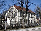
Primary school (old building)

Oselstrasse 28

Oselstrasse 36


Individual evidence
- ↑ Street studies - told about the Pasinger archive. Pasinger Archive website (accessed January 30, 2020).
literature
- Denis A. Chevalley, Timm Weski: State Capital Munich - Southwest (= Bavarian State Office for Monument Preservation [Hrsg.]: Monuments in Bavaria . Volume I.2 / 2 ). Karl M. Lipp Verlag, Munich 2004, ISBN 3-87490-584-5 , p. 474 .
Web links
Coordinates: 48 ° 9 ′ 14.5 ″ N , 11 ° 27 ′ 39.4 ″ E