Otter Creek, Vermont
| Otter Creek | ||
|
The Otter Creek Falls in Vergennes |
||
| Data | ||
| Water code | US : 1460510 | |
| location | Vermont (USA) | |
| River system | Saint Lawrence River | |
| Drain over | Rivière Richelieu → Saint Lawrence River → Atlantic Ocean | |
| source | at Mount Tabor in Danby 43 ° 22 ′ 29 ″ N , 72 ° 59 ′ 52 ″ W. |
|
| muzzle |
Lake Champlain Coordinates: 44 ° 13 ′ 32 " N , 73 ° 19 ′ 29" W 44 ° 13 ′ 32 " N , 73 ° 19 ′ 29" W |
|
| Mouth height |
29 m
|
|
| length | approx. 180 km | |
| Catchment area | 2385 km² | |
| Right tributaries | Mill River , Cold River , Leicester River , New Haven River | |
| Communities | Clarendon , Rutland , Pittsford , Brandon , Middlebury , Weybridge , New Haven , Vergennes | |
| Navigable | from the estuary to Vergennes | |
|
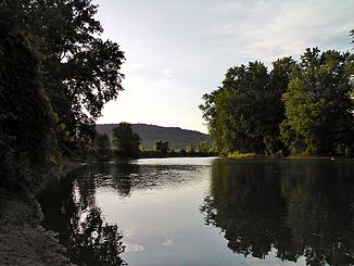
Otter Creek in Weybridge |
||
The Otter Creek is a river in Vermont in the United States .
Its length is usually given as about 180 km. This makes it one of the longest rivers in Vermont. In the literature, however, there are very divergent information on this length specification; the official sources are silent about a length specification. The exact catchment area is also not defined.
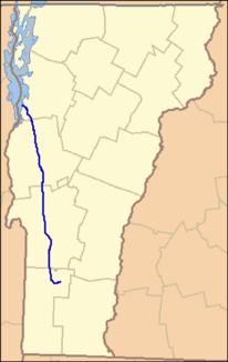
The Otter Creek rises on the western flank of Mount Tabor , first flows south, then after a few kilometers turns in a large arc to the north and flows in a largely straight line towards Lake Champlain, into which it then flows. It flows through the main settlements of several towns ; in three of them - Middlebury , Weybridge and Vergennes - the otherwise calm river tumbles over smaller waterfalls. For this reason, Otter Creek is only navigable from the mouth to the first of these falls in Vergennes. While the river was also used for transport shipping until the 1970s - supported by the opening of the Bellows Falls – Burlington railway line in 1847, which follows the course of the river valley on the west side of the Green Mountains - the waterway is now used exclusively for recreational sports is used extensively by both canoeists and anglers. Motorboats are also common near the estuary.
On its way north, the river forms several swamps; Of these, the largest area with around 4,200 hectares, the Cornwall Swamp , has been a nature reserve since 1974 as the Otter Creek Swamps Nature Park . It is the largest nature reserve in Vermont.
In the British-American War of 1812, the American fleet for Lake Champlain was laid down below the waterfalls in Vergennes. To protect the fleet, Fort Cassin was built at the mouth of the river , after which this point is named to this day.
Web links
- Vermont Water Quality Planning Section - Otter Creek Basin
- Homepage of the nature reserve Otter-Creek-Swamps (English)
Individual evidence
- ^ Otter Creek in the Geographic Names Information System of the United States Geological Survey
- ↑ George C. Daughan: 1812: The Navy's War . 1st edition. Basic Books, New York 2011, ISBN 0-465-02046-1 , pp. 265 .


