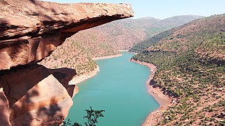
Lakhdar (river)
|
Oued Lakhdar Oued Tessaout |
||
|
Hassan I reservoir |
||
| Data | ||
| location | Morocco | |
| River system | Oum er-Rbia | |
| Drain over | Oum er-Rbia → Atlantic Ocean | |
| source |
High Atlas about 35 km southeast of Azilal 31 ° 47 ′ 17 ″ N , 6 ° 22 ′ 43 ″ W |
|
| Source height | approx. 1200 m | |
| muzzle | south of El Borouj in the Oum er-Rbia Coordinates: 32 ° 22 ′ 5 " N , 7 ° 14 ′ 10" W 32 ° 22 ′ 5 " N , 7 ° 14 ′ 10" W |
|
| Mouth height | approx. 285 m | |
| Height difference | approx. 915 m | |
| Bottom slope | approx. 5.1 ‰ | |
| length | approx. 180 km | |
| Reservoirs flowed through | Hassan I reservoir | |
The 180 km long Oued Lakhdar is a tributary of the Oum er-Rbia on the north side of the High Atlas in the regions of Béni Mellal-Khénifra and Marrakech-Safi in southern Morocco .
course
The Oued Lakhdar rises southeast of the village of Ait M'hamed approx. 25 km southeast of Azilal and initially runs in a westerly direction and feeds the Hassan I reservoir ; after passing the border to the Marrakech-Safi region , it turns to the northwest, then later to the north, where it finally flows into the Oum er-Rbia as Oued Tessaout about 15 km south of the town of El Borouj .
economy
The Oued Lakhdar is mainly used to irrigate the agricultural areas along its riparian zones.
places
There are only small towns on the banks of the river.
See also
- About 30 km to the east, the Oued El Abid also joins the Oum er-Rbia.
