Oukaïmeden
| Oukaïmeden ⵓⴽⴰⵢⵎⴷⴰⵏ |
||||
|---|---|---|---|---|
|
||||
| Basic data | ||||
| State : |
|
|||
| Region : | Marrakech-Safi | |||
| Province : | Al Haouz | |||
| Coordinates | 31 ° 12 ′ N , 7 ° 52 ′ W | |||
| Residents : | 4,861 (2014) | |||
| Height : | 2700 m | |||
| Mountain lake near Oukaïmeden | ||||

Oukaïmeden ( Arabic أوكايمدن, Central Atlas Tamazight ⵓⴽⴰⵢⵎⴷⴰⵏ Ukaymedan ) is a rural municipality (commune rurale) with about 5,000 inhabitants in the center of the High Atlas in the province of Al Haouz in the region Marrakech-Safi in Morocco . Oukaïmeden is better known as a ski station with corresponding hotels, guest houses and restaurants.
location
The village is about 2600 m high and is located almost 80 km (driving distance) south of the city of Marrakech in the middle of the Toubkal National Park and can be reached from the Ourika Valley via the narrow and winding mountain road P2030. The climate is alpine; the precipitation (rain and snow) is relatively high for Moroccan conditions (approx. 700 mm / year).
population
| year | 1994 | 2004 | 2014 |
| Residents | 3,798 | 4,440 | 4,861 |
In Oukaïmeden there are families from the Berber tribe who live in traditional stone huts and raise sheep and goats in the summer months.
history
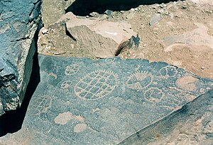
The presence of rock carvings ( petroglyphs ) with mostly abstract motifs suggests that the area was first visited in prehistoric times by hunters and gatherers , and later possibly also by cattle nomads ( transhumants ) who found summer pastures for their herds of sheep and goats .
Attractions
- The mountain town has no special attractions. However, it does offer wealthier Moroccans and Europeans from Marrakech a welcome cooling off in the hot summer months. In winter, ski lifts are in operation that lead to an altitude of over 3200 m.
- Countless boulders offer opportunities for bouldering . Some of the steep walls in the area can be climbed .
- Surroundings
- In the near and far surroundings of Oukaïmeden there are many rock carvings from around 6000 BC. Until about 2000 BC Chr .; some are dated even more recently. The specialty of many petroglyphs in the vicinity of Oukaïmeden are their abstract geometric shapes, which are difficult to interpret.
- From Oukaïmeden you can also go on multi-day mountain hikes to Imlil or Setti Fatma . A 3 to 4 day ascent of Jbel Toubkal ( 4167 m ) is also possible.


