Palapaso
| Palapso | |||

|
|||
|
|
|||

|
|||
Palapaso (Palapaço) is a district of the East Timorese capital Dili .
geography
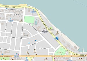
Palapso is located in the northeast of the Sucos Motael, on the Bay of Dili . South of Rua de Santo Antônio and Rua Karketu Mota'ain is the Farol district , Aitarak to the west and Bebora to the south- west . Sometimes aitarak and palapaso are included in farol. The Avenida de Motael runs along the coast . Rua de Palapaço is located further west on the border of the Sucos Motael to Kampung Alor .
history
East Timor was occupied by Indonesia from 1975 to 1999 . On October 27, 1991, East Timorese Sebastião Gomes was shot by Indonesian security forces and bled to death in the Church of Santo António de Motael . At his funeral there was a demonstration for the independence of East Timor. The result was a massacre of the demonstrators by Indonesian security forces, the so-called Santa Cruz massacre .
In 2006 a camp was set up at Motael Church to provide shelter for refugees after the 2006 riots in East Timor .
Sights and facilities
Santo António de Motael, on the southern edge of Palapso, was the cathedral of Dili between the end of World War II and the completion of the new building in 1988. Reminiscent of the Santa Cruz massacre in lying in front Jardim Motael the monument to the Santa Cruz massacre (also Estátua da Juventude ).
The Motaels lighthouse is on the north bank of Palapso; Not in Farol ( Portuguese lighthouse ), as one might expect from the name. Opposite, in a colonial villa that was renovated in 2003 with Korean help, is the Ministry of Tourism to the west of the Direção de Minerais of the Autoridade Nacional do Petróleo e Minerais (ANPM) and to the east of the Thai embassy. Jardim Borja is located south of the Ministry of Tourism on Rua dos Direitos Humanos .
Direção de Minerais of the Autoridade Nacional do Petróleo e Minerais ANPM
Web links
Individual evidence
- ↑ UNMIT: Timor-Leste District Atlas version 02, August 2008 ( Memento from December 3, 2011 in the Internet Archive ) (PDF; 448 kB)
- ↑ Memorial plaque on the building (in Portuguese and English)
Coordinates: 8 ° 32 ′ 59 ″ S , 125 ° 34 ′ 9 ″ E


